This area is one of singular beauty from different viewpoints; from the geological viewpoint, with its remains of marine animal fossils, more than 300 million years old, from the botanical viewpoint, with its extension of beech and oak trees in the basins of the rivers that cross it, from the historical viewpoint, due to the remains that have been preserved from the main historical events and from the leisure viewpoint, due to the recreational areas and walks.
We take the concrete track that begins next to the information booth and, after about 30 meters, we walk on the dirt track that goes to the right.
Along this path, which runs parallel to the road, we pass through a recreational area set in an old beech tree nursery and arrive at the Gorostardi car park. At the beginning of the track that starts on the left of the road, there is a signpost.
Following the direction of “San Anton” we continue to the next signpost located at the crossroads of Erroiarriko lepoa.
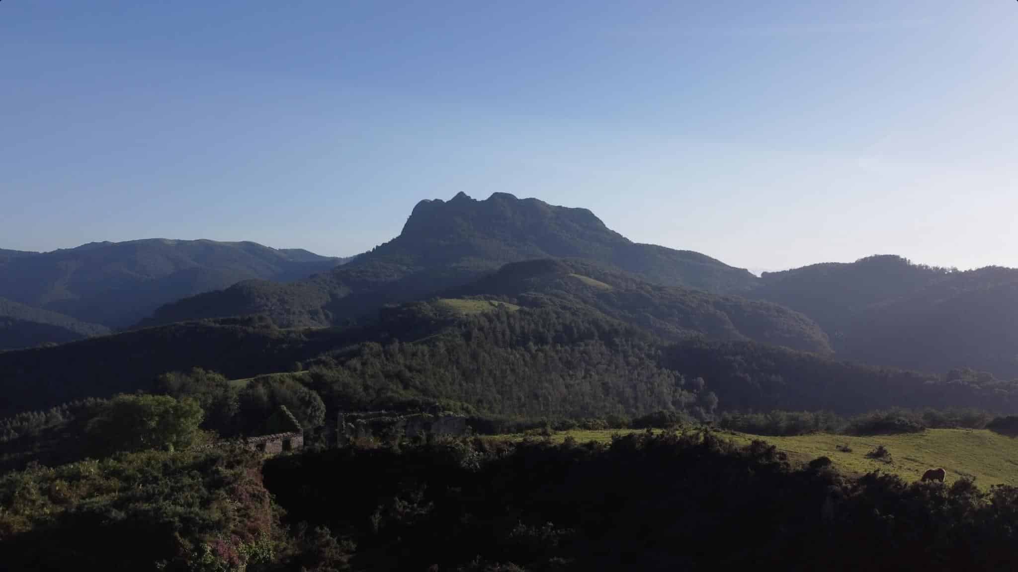
From here, we can optionally climb up to Erroiarri crest (be careful when passing by the electric tower. DO NOT TOUCH!) from where we can enjoy magnificent views of Endara valley, Aiako Harria and the surrounding mountains. Following the marked route, from the crossroads take the track on the left towards Erlaitz. The path passes through sections of mature oak woods and open areas where new trees have been planted to regenerate the forest.
We will cross several streams bordered with alders. After crossing a small pine grove we get to a concrete track. We take this track to the right, cross a small car park next to a farmhouse and take the dirt track on the left.
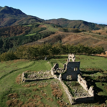
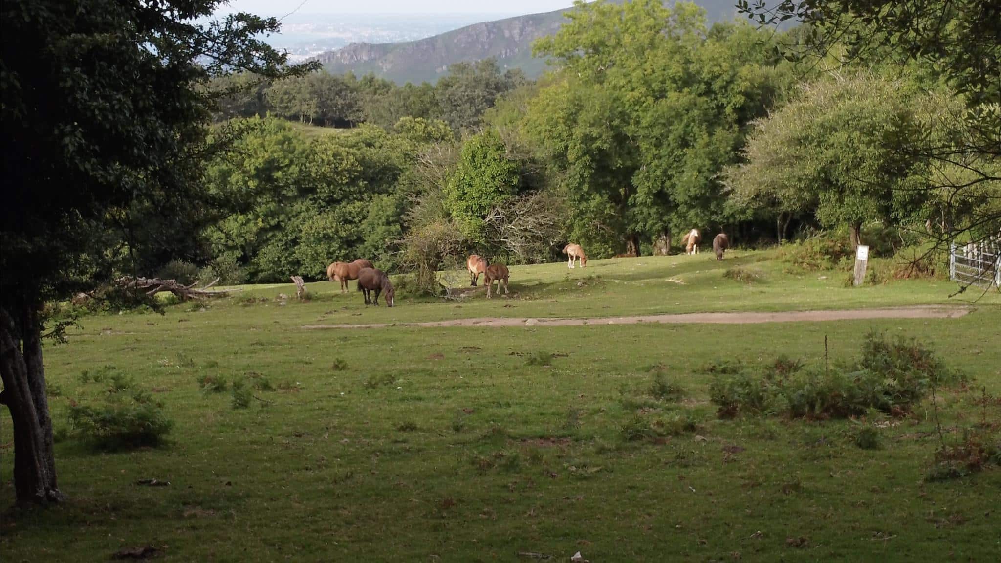
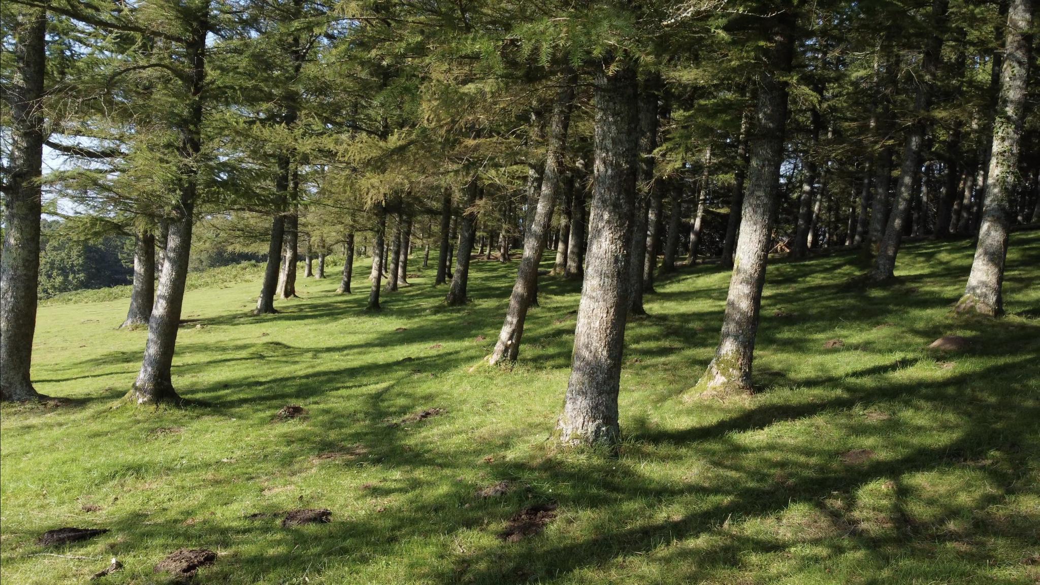
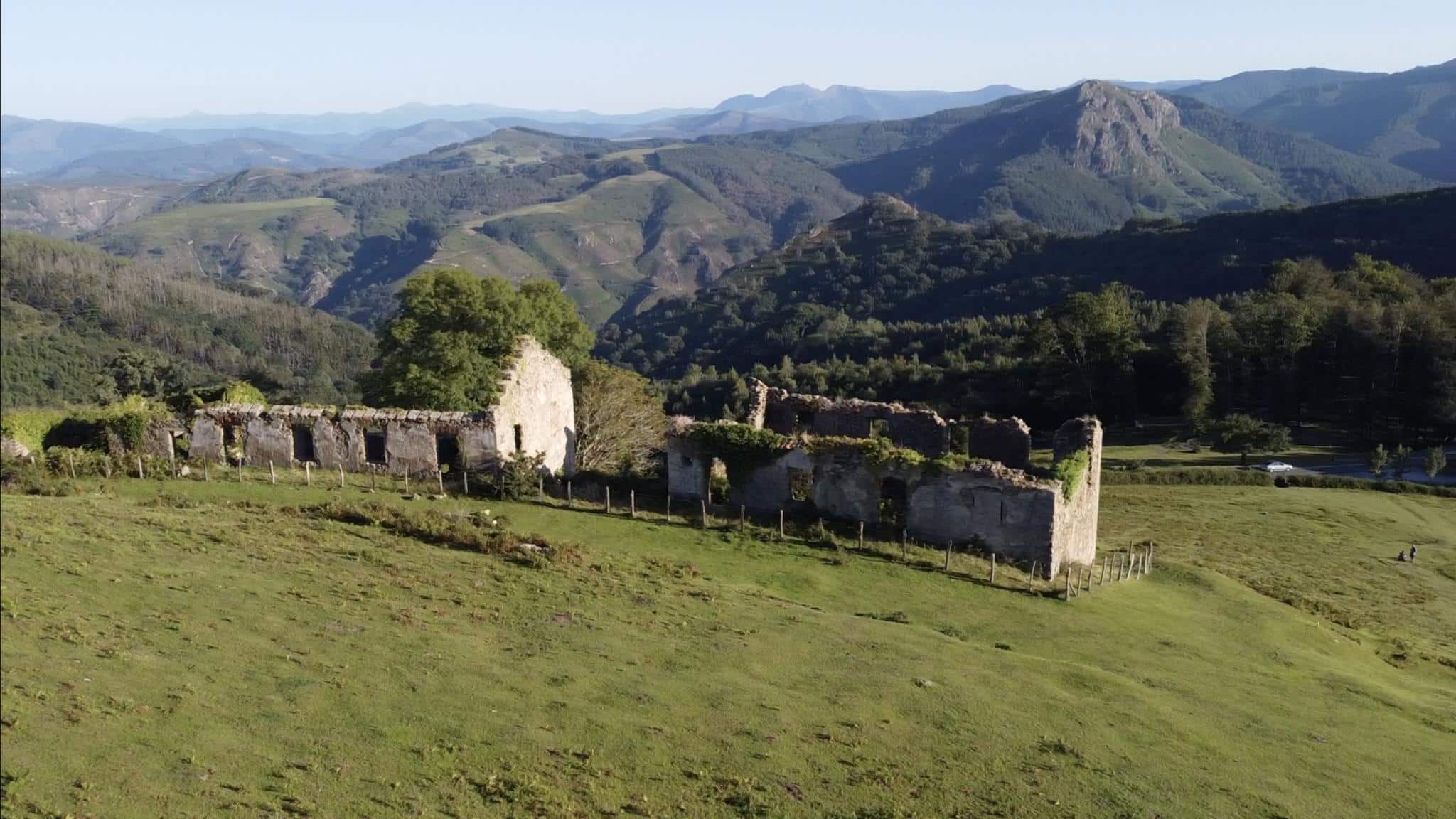
We continue along this track until we reach the ridge that descends to Endarlaza. Here we turn left and go uphill along the path that goes up to Pagogaina meadows. We continue between pastures and bushes. Sheep, cows and mares graze freely in these open areas and it is easy to observe vultures and other birds of prey. We cross a small larch grove and pass by the ruins of Pagogaina Fort (19th century).
The path descends until it reaches the starting point again, where the milestone of “La Pena de Vida” (The death penalty) is located. It was placed in the 17th century as a warning: “From here, desertion leads to death penalty”.
Erlaitz fort/ Meazuri mines . AITZONDO WATERFALL
From the information booth, we take the road towards Irun. After about 70 m, we take the dirt track that starts on the left and goes up to the ruins of the Erlaitz barracks.
At the top of the hill we can see the surrounding landscape and, with due caution, the excavations that were carried out in the 19th century for the construction of the failed Erlaitz fort. We descend a gentle slope towards the Sorotxiki car park from where we take the forest track that descends to the right. The track runs through a pine forest. To avoid getting lost, we recommend following the signs that identify the route. After a series of bends and a stream, we enter the oak forest of Enbido.
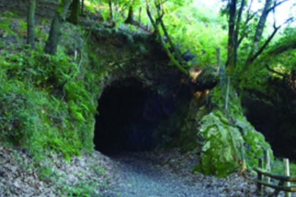
It is a mass of American oak planted at the beginning of the twentieth century, with large specimens. We follow the path to the crossroads, where we turn right. We continue the path through five tunnels dug for the mining railway. Magnificent views of Aitzondo waterfall and ravine. After crossing the tunnels we continue along the railway path. Along the way we will see the remains of the mining activity (pitheads, shacks, barracks). Following the trail marks, the path climbs up the track that will take us back to the road, and finally to Gorostardi car park. We cross the road and the recreational area, then we continue along the track that runs parallel to the road. We end up at the starting point next to the Lapurriturri information booth.
From Elurretxeko Lepoa car park we cross the road and take the wide track that starts on the other side, where we walk between pine and oak groves. At a crossroads, a path begins on the left through a beech plantation.
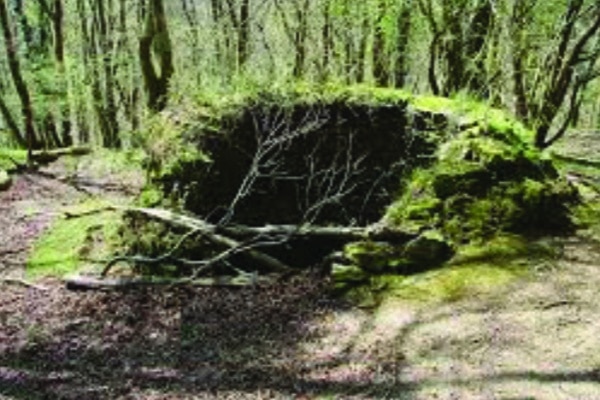
Optionally, if we continue on the same track, we reach the Arburu rocks from where we can enjoy beautiful views over the bay and Jaizkibel mountain. Otherwise, we follow the marked trail that starts at the beech plantation, always paying attention to the signs. The path goes through different types of tree plantations and native woods, near Lutegiko Borda ice-pit, with the remains of a vault (be cautious when approaching). We continue along the path until we reach the high voltage power line.
Here we take the path to the left and descend steeply down the power line until we reach Sarjiñola stream. We cross the stream and follow the track that goes up the slope. Following the marks, the path takes us through a woodland resulting from old plantations of oak, pine and cypress. After passing by Sarjiñola recreational area the path reaches the road. We cross it and take the track that enters the Castillo del Inglés estate. We cross the fence and continue on the path next to the ruins of the old mining works.
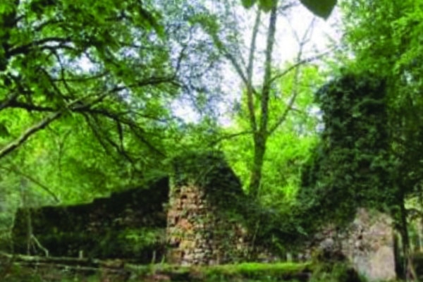
We pass over the railway bridge and next to the remains of the house of the English engineer who ran the premises (hence the name of the “Englishman’s castle”). We cross the estate and go out through another gate. In the beech forest, next to the path, we find another ice-pit, Aireko Soroa. The path continues its descent until we get to the starting point in Elurretxeko lepoa car park. Optionally, we can also visit the nearby Elurretxe ice-pit. To do this, follow the road towards Irun and, about 70 m from the car park, take the path on the left, on the slope of the road. A few metres away, on the right of the trail and underneath it, you will find the ice-pit.
The starting point is the car park of Ibarla, opposite a recreational area. The trail begins at this point and follows the white and green marks all the way. From the car park we cross the stream through a small bridge and arrive at the old mining railway; today it’s a pedestrian-cyclist path. We walk upstream along this path for a while. The trail passes by the Ola forge, the fish farm where the Gipuzkoa Provincial Council raises salmon for the restocking of rivers, and a hydroelectric power station.
The Irugurutzeta furnaces are just ahead. Once at the furnaces, we follow the white and green marks towards Aitzondo waterfall. From here we can access another section of the mining railway that connects the waterfall and the furnaces by means of two inclined planes. After a climb up the first inclined plane, which is undoubtedly demanding but not insurmountable, we’ll walk on a flat section of the old railway.
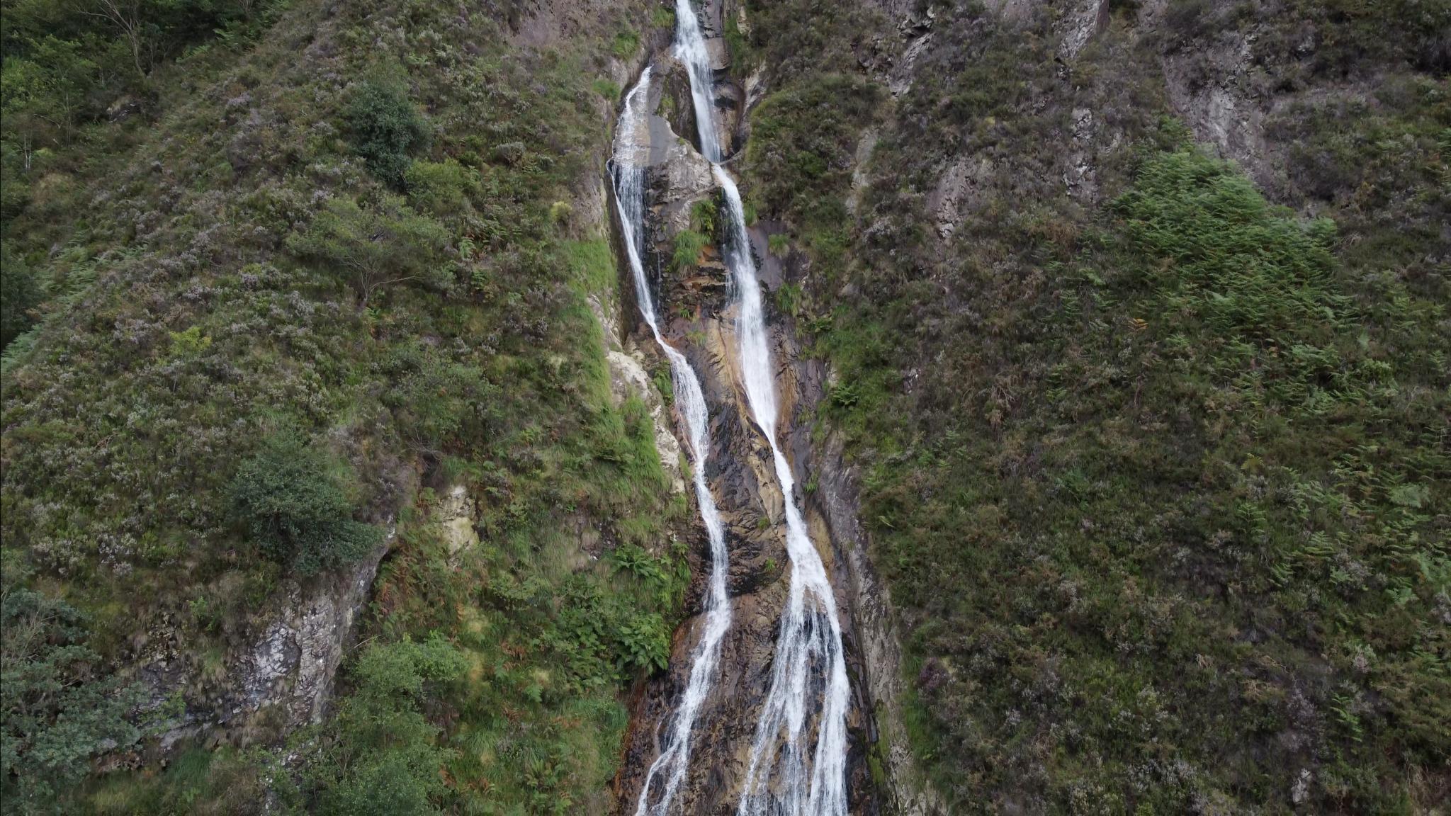
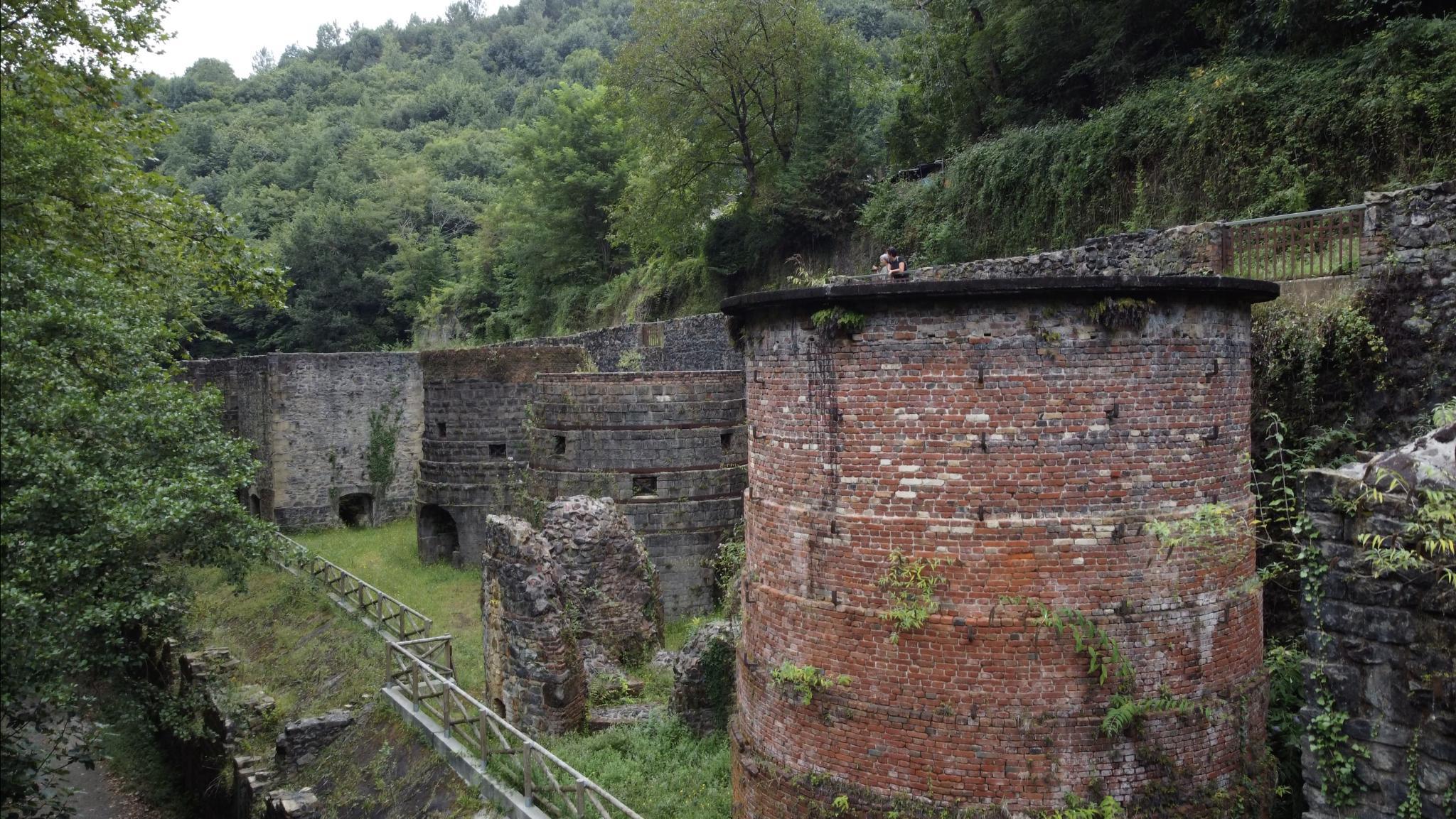
Here we see the remains of the mining works, mainly iron ore, which were active until the beginning of the 20th century. The landscape closes up to form a ravine with steep slopes. After crossing a small bridge, we reach the second inclined plane, made of steps. After this second climb we get to a wide track. From this point, we can reach the base of the Aitzondo waterfall. To do so, we need to follow the track to the left and pass by the ruins of an old mining shack located next to a closed mine entrance. This section requires caution as the path is steep and can be slippery.
Following the marked trail, after the last inclined plane, we turn right along the track. This dirt track leads to a concrete road that will take us downhill. Without deviating from this road, we will reach the Ola cider farm. From here we return by the pedestrian-cyclist path to the starting point in Ibarla car park.
La paroisse de l’Assomption et du Pommier n’est pas accessible aux personnes ayant une diversité fonctionnelle physique. L’entrée principale étant située à un niveau plus élevé que la rue, le dénivelé est comblé par une volée de six marches. En outre, la porte d’accès principale présente une autre légère différence de niveau, comblée par une marche.
En termes de diversité fonctionnelle visuelle, l’accessibilité n’est pas garantie en raison de l’orientation visuelle existante ; si les panneaux et indications sont bien lisibles et suffisants, ils ne sont pas conformes à la réglementation. De plus, aucun système d’orientation tactile n’est mis en place.
Quant à l’orientation auditive, l’espace est considérée comme moyennement accessible car l’information visuelle et écrite est bien présente, mais évaluée comme insuffisante.

La diversité fonctionnelle organique n’est pas correctement prise en compte, étant donné que le large spectre de maladies qu’elle couvre n’est pas pris en considération. Un ample éventail de services minimums devrait être mis en place, notamment en termes de satisfaction des besoins humains fondamentaux (toilettes, sources d’eau potable, gestion des déchets médicaux, etc.).

Le degré d’accessibilité en matière de diversité fonctionnelle intellectuelle n’a pas pu être évalué par manque d’information.
La plage de Hondarribia est située à l’extrémité orientale du littoral de Gipuzkoa, plus précisément dans la baie de Txingudi, à proximité de l’embouchure du fleuve Bidassoa.
Au regard de la diversité fonctionnelle physique, la plage est considérée comme accessible, car elle dispose d’accès adaptés aux personnes à mobilité réduite (rampes d’accès et passerelles rigides sur le sable). Elle dispose également de places de parking réservées aux personnes à mobilité réduite, ainsi que de toilettes adaptées, et offre un service de baignade assistée.
En termes de diversité fonctionnelle visuelle, la plage est considérée comme moyennement accessible, puisqu’un système de sonorisation permet de diffuser les annonces importantes. En ce qui concerne la diversité fonctionnelle auditive, la plage n’est pas considérée comme accessible car aucun système d’orientation auditive n’est offert. Il n’y a pas non plus d’instructions ou d’informations disponibles en langue des signes.
L’accessibilité en termes de diversité fonctionnelle organique est garantie en raison des services minimums offerts, notamment en termes de satisfaction des besoins humains fondamentaux (toilettes, sources d’eau potable, gestion des déchets médicaux, etc.) et de possibilité de se reposer.
Le degré d’accessibilité en matière de diversité fonctionnelle intellectuelle n’a pas pu être évalué par manque d’information.
Le quartier historique de Hondarribia correspond à l’ancienne enceinte fortifiée de la ville, qui conserve une partie importante des murailles et des bastions qui l’entourent, ainsi que les deux portes d’accès à la forteresse.
A l’intérieur du quartier historique, les rues forment un plan rectangulaire de rues pavées et de bâtiments à balcons en fer forgé. De manière générale, les rues présentent une section type composée d’une chaussée centrale avec des pavés et des trottoirs des deux côtés, en dalles de calcaire, qui sont surélevées. Ce sont des rues très étroites où les trottoirs n’ont pas les dimensions minimales pour les rendre accessibles aux personnes ayant une diversité fonctionnelle physique. De plus, certaines rues ont de fortes pentes et à certains endroits, les différences de niveau sont comblées par une volée de marches.
En termes de diversité fonctionnelle visuelle, l’accessibilité n’est pas garantie en raison de l’inexistence d’éléments d’orientation visuelle, tels que le marquage de la chaussée. Le fait que le quartier historique soit protégé et déclaré Site Monumental rend difficile toute action dans ce sens.
En ce qui concerne l’orientation auditive, le site est considéré comme moyennement accessible car l’information visuelle et écrite est bien présente, mais évaluée comme insuffisante.
La diversité organique fonctionnelle n’est pas correctement prise en compte, étant donné que le large spectre de maladies qu’elle couvre n’est pas pris en considération. Un ample éventail de services minimums devrait être mis en place, notamment en termes de satisfaction des besoins humains fondamentaux (toilettes, sources d’eau potable, gestion des déchets médicaux, etc.), et de possibilité de se reposer.
Le degré d’accessibilité en matière de diversité fonctionnelle intellectuelle n’a pas pu être évalué par manque d’information.
L’auditorium Itsas Etxea est pleinement accessible aux personnes présentant une diversité fonctionnelle physique, les accès, les marches, l’accueil, le mobilier, etc. étant conformes à la réglementation en vigueur en matière d’accessibilité. Bien que les gradins ne disposent pas de rampe d’accès, des places sont réservées aux personnes à mobilité réduite, en bas de l’auditorium.
En termes de diversité fonctionnelle visuelle, l’accessibilité n’est pas garantie en raison de l’orientation visuelle existante ; bien que les panneaux et indications soient lisibles, ils sont insuffisants. De plus, aucun système d’orientation tactile n’est mis en place.
En ce qui concerne la diversité fonctionnelle auditive, l’espace est considéré comme accessible car, outre les panneaux de signalisation et écrits, il dispose de systèmes d’induction auditive tels que la boucle à induction magnétique.
L’espace est considéré comme accessible en termes de diversité fonctionnelle organique, car il offre des services minimums, notamment en termes de satisfaction des besoins humains fondamentaux (toilettes, fontaines d’eau potable, gestion des déchets médicaux, etc.), et de possibilité de se reposer.
Le degré d’accessibilité en matière de diversité fonctionnelle intellectuelle n’a pas pu être évalué par manque d’information.
Hondarribia dispose d’un deuxième office de tourisme situé dans la rue Matxin de Artzu, dans le quartier de la Marina. Le bureau n’est pas accessible aux personnes ayant une diversité fonctionnelle physique, dû à un accès disposant d’une porte très étroite et, de manière générale, peu accessible.
En termes de diversité fonctionnelle visuelle, l’espace n’est pas accessible car il n’y a aucun type d’indication, de panneau ou de signalisation, ni aucun système d’orientation tactile. De plus, étant visuellement très confus, il très difficile de s’y orienter. En ce qui concerne l’orientation auditive, des informations visuelles et écrites sont présentes, mais insuffisantes.
La diversité fonctionnelle organique est bien prise en compte, car le large spectre de maladies qu’elle englobe est pris en considération, offrant ainsi un large éventail de services minimums, notamment en termes de satisfaction de besoins humains fondamentaux (toilettes publiques à proximité, sources d’eau potable, gestion des déchets médicaux, etc.) et de possibilité de se reposer. Le degré d’accessibilité en matière de diversité fonctionnelle intellectuelle n’a pas pu être évalué par manque d’information.
Quant au site web www.bidasoaturismo.com, il est conforme aux protocoles WAI, étant facilement compréhensible et maniable.
Le Centre d’Information Culturelle et Touristique est situé sur la Plaza de Armas, en face du château de Charles Quint, au cœur du centre historique. Une amélioration de l’accès au bureau est nécessaire, afin de permettre aux personnes, ayant une diversité fonctionnelle physique, d’y accéder. L’accès depuis l’ascenseur est difficile, dû à un sol inadapté, peu sécurisé, à un espace insuffisamment éclairé et à une porte très lourde.
En termes de diversité fonctionnelle visuelle, l’espace n’est pas accessible en raison des panneaux et indications lisibles mais très insuffisants, et d’un environnement visuellement peu balisé. De plus, il n’y a aucun système de guidage tactile. En ce qui concerne l’orientation auditive, des informations visuelles et écrites sont présentes, toutefois, insuffisantes.
La diversité fonctionnelle organique n’est pas correctement assistée, car le large spectre de maladies qu’elle englobe n’est pas pris en considération. Un ample éventail de services minimums, devraient être inclus notamment en termes de satisfaction de besoins humains fondamentaux (toilettes, sources d’eau potable, gestion des déchets médicaux, etc.) et de possibilité de se reposer.
Le degré d’accessibilité en matière de diversité fonctionnelle intellectuelle n’a pas pu être évalué par manque d’information.
Jasokundeko eta Sagarrondoko Andre Maria parrokia ez da irisgarria aniztasun funtzional fisikoa duten pertsonentzat; izan ere, sarbide nagusia kalea baino kota handiagoan dago, eta sei eskailera maila igo behar dira sartzeko. Gainera, sarrera nagusiko ateak beste desnibel txiki bat du, maila bat duena.
Aniztasun funtzional bisualari dagokionez, ez da irisgarria; izan ere, orientazio bisualak, kartelak eta adierazpenak irakurtzeko modukoak eta nahikoak izan arren, ez du araudia betetzen. Gainera, ez dago ukipen orientazioko sistemarik.
Entzumen orientazioari dagokionez, nahiko irisgarritzat jotzen da, informazio bisuala eta idatzia bai baitago, baina ez da nahikoa.
Aniztasun funtzional organikoa ez dago behar bezala zaindua, ez baita kontuan hartzen bere baitan duen gaixotasun sorta zabala, eta zerbitzu minimo ugari beharko lirateke, batez ere oinarrizko giza premiak asetzeari dagokionez (komunak, edateko uraren iturriak, hondakin medikoen kudeaketa, etab.).
Aniztasun funtzional intelektualaren irisgarritasun maila ezin izan da ebaluatu informazio faltagatik.
Hondarribiko hondartza Gipuzkoako itsasertzaren ekialdeko muturrean dago, zehazki Txingudiko badian, Bidasoa ibaiaren bokalearen ondoan.
Hondartza irisgarria da aniztasun funtzional fisikoari dagokionez, mugikortasun urriko pertsonentzako sarbide bereziak baititu (sartzeko arrapalak eta korridore zurrunak hondarretan). Gainera, mugikortasun urriko pertsonentzat erreserbatutako aparkaleku plazak ditu, bainugela egokituak ditu eta bainu lagundua eskaintzen du.
Aniztasun funtzional bisualari dagokionez, nahiko irisgarritzat jotzen da, abisu garrantzitsuak emateko megafonia zerbitzua baitu. Entzumen aniztasun funtzionalari dagokionez, ez da irisgarria, ez baitu entzumen orientazioko sistemarik. Zeinu hizkuntzan ere ez dago jarraibiderik edo informaziorik.
Aniztasun funtzional organikoari dagokionez, irisgarritzat jotzen da, gutxieneko zerbitzuak eskaintzen baititu, batez ere oinarrizko giza premiak asetzeari dagokionez (bainuak, edateko uraren iturriak, hondakin medikoen kudeaketa, etab.), bai eta atseden hartzeko aukera ere.
Aniztasun funtzional intelektualaren irisgarritasun maila ezin izan da ebaluatu informazio faltagatik.
Hondarribiko hirigune historikoa hiribilduko antzinako harresi barrutiaren barruan dago, eta inguruko harresien eta bastioien parte handi bat kontserbatu da, bai eta gotorlekura sartzeko bi ateak ere.
Hirigune historikoaren barruan, oinplano angeluzuzena osatzen dute kaleek, harrizko zoladurarekin eta burdina forjatuzko balkoiekin. Oro har, kaleen sekzio tipoa galtzada nagusi batek eratzen du, galtzada harriz osatua eta espaloiak ditu bi aldeetan, kareharrizko lauzekin. Lauzak goratuak daude. Oso kale estuak dira, eta espaloiek ez dute gutxieneko neurririk aniztasun funtzional fisikoa duten pertsonentzat irisgarriak izateko. Era berean, kale batzuek oso aldapa handiak dituzte, eta zenbait puntutan, koten arteko aldeak eskailera tarte baten bidez baino ez dira gainditzen.
Aniztasun funtzional bisualari dagokionez ere ez da irisgarria, ez baitu orientazio bisualeko elementurik, hala nola zoladura bidezko seinaleztapena. Hirigune historikoa babestua eta monumentu multzo izendatua izateak zaildu egiten ditu ildo horretan ekintzak bideratzea.
Entzumen orientazioari dagokionez, nahiko irisgarritzat jotzen da, informazio bisuala eta idatzia bai baitago, baina ez da nahikoa.
Aniztasun funtzional organikoa ez dago behar bezala zaindua, ez baita kontuan hartzen bere baitan duen gaixotasun sorta zabala, eta zerbitzu minimo ugari beharko lirateke, batez ere oinarrizko giza premiak asetzeari dagokionez (komunak, edateko uraren iturriak, hondakin medikoen kudeaketa, etab.), bai eta atseden hartzeko aukera ere.
Aniztasun funtzional intelektualaren irisgarritasun maila ezin izan da ebaluatu informazio faltagatik.
Itsas Etxea auditoriuma erabat irisgarria da aniztasun funtzional fisikoa duten pertsonentzat, eta indarrean dagoen irisgarritasun araudia betetzen dute sarbideak, pasabideek, harrerak, altzariek eta abarrek. Harmailek arrapalarik ez duten arren, mugikortasun urriko pertsonentzat gordetako eserlekuak badaude auditoriumaren beheko aldean.
Aniztasun funtzional bisualari dagokionez, ez da irisgarria; izan ere, orientazio bisuala, kartelak eta adierazpenak irakurtzeko modukoak badira ere, ez dira nahikoa. Gainera, ez dago ukipen orientazioko sistemarik.
Entzumen aniztasun funtzionalari dagokionez, irisgarritzat jotzen da; izan ere, bideko eta idatzizko informazioaz gain, entzuteko indukzio sistemak ere baditu, begizta magnetikoa kasu.
Aniztasun funtzional organikoari dagokionez, irisgarritzat jotzen da, gutxieneko zerbitzuak eskaintzen baititu, batez ere oinarrizko giza premiak asetzeari dagokionez (bainuak, edateko uraren iturriak, hondakin medikoen kudeaketa, etab.), bai eta atseden hartzeko aukera ere.
Aniztasun funtzional intelektualaren irisgarritasun maila ezin izan da ebaluatu informazio faltagatik.
Hondarribiak bigarren turismo bulego hau du Matxin Artzu kalean, Portua auzoan. Bulegoa ez da irisgarria aniztasun funtzional fisikoa duten pertsonentzat; izan ere, sarrerako atea oso estua da, eta, oro har, ez da irisgarria.
Aniztasun funtzional bisualari dagokionez, ez da irisgarria, ez baitago inolako adierazpen, kartel edo seinalerik, eta ez baitago ukipen orientaziorako sistemarik. Gainera, bisualki oso nahasia da, eta oso zaila da orientatzea. Entzumen orientazioari dagokionez, informazio bisuala eta idatzia badago, baina ez da nahikoa.
Aniztasun funtzional organikoa behar bezala zaindua dago, kontuan hartzen baita bere baitan duen gaixotasun sorta zabala, hau da, zerbitzu minimo ugari daude, batez ere oinarrizko giza premiak asetzeari dagokionez (komunak, edateko uraren iturriak, hondakin medikoen kudeaketa, etab.), bai eta atseden hartzeko aukera ere. Aniztasun funtzional intelektualaren irisgarritasun maila ezin izan da ebaluatu informazio faltagatik.
Bestalde, www.bidasoaturismo.com webguneak WAI protokoloak betetzen ditu, erraz ulertzeko eta erabiltzeko modukoa baita.
Kultur eta Turismo Informazio Gunea Arma plazan dago, Karlos V.aren gazteluaren aurrean, hirigune historikoaren erdian. Bulegorako sarbidea hobetu egin behar da, aniztasun funtzional fisikoa duten pertsonak bertara joan ahal izateko. Igogailutik sartzea zaila da; izan ere, zorua desegokia da, ez da segurua, argiztapen txikia du eta atea oso astuna da.
Aniztasun funtzional bisualari dagokionez, ez da irisgarria; izan ere, kartelak eta argibideak irakurtzeko modukoak dira, baina oso gutxi dira, eta ingurunea ez dago oso balizatua bisualki. Gainera, ez dago ukipen orientazioko sistemarik. Entzumen orientazioari dagokionez, informazio bisuala eta idatzia badago, baina ez da nahikoa.
Aniztasun funtzional organikoa ez dago behar bezala zaindua, ez baita kontuan hartzen bere baitan duen gaixotasun sorta zabala, eta zerbitzu minimo ugari beharko lirateke, batez ere oinarrizko giza premiak asetzeari dagokionez (komunak, edateko uraren iturriak, hondakin medikoen kudeaketa, etab.), bai eta atseden hartzeko aukera ere.
Aniztasun funtzional intelektualaren irisgarritasun maila ezin izan da ebaluatu informazio faltagatik.
The Asunción y del Manzano Church is not accessible for people with physical functional diversity, as the main access is at a higher level than the street, with a flight of six steps. Furthermore, the main entrance has another small step.
As for visual functional diversity, it is not accessible because, although the posters and signs are legible and sufficient in number, they do not comply with regulations. In addition, there is no tactile guidance system.
In terms of auditory guidance, it is considered moderately accessible as there is visual and written information, although this is considered insufficient.
Organic functional diversity is not properly catered for as the wide spectrum of conditions it covers is not considered, and this should translate into a wide range of minimum services, especially in terms of meeting basic human needs (toilets, drinking fountains, medical waste management, etc.).
The degree of accessibility in terms of intellectual functional diversity could not be assessed due to lack of information.
Hondarribia beach is located at the eastern end of the Gipuzkoan coastline, more specifically in Txingudi Bay, next to the mouth of the Bidasoa River.
The beach is accessible in terms of physical functional diversity as it has special access for people with reduced mobility (access ramps and rigid walkways on the sand). There are also parking spaces reserved for people with reduced mobility, adapted toilets and assisted bathing services.
Regarding visual functional diversity, the beach is considered moderately accessible as it has a public address system for important announcements. In relation to auditory functional diversity, it is not accessible as it lacks auditory orientation systems. Nor are there any instructions or information in sign language.
It is considered accessible in terms of organic functional diversity as it offers minimum services, especially in terms of meeting basic human needs (toilets, drinking water fountains, medical waste management, etc.) and resting possibilities.
The degree of accessibility in terms of intellectual functional diversity could not be assessed due to lack of information.
The historic town of Hondarribia is located to the old walled enclosure of the town. A great part of the surrounding walls and bastions have been preserved, as well as the two main gates giving access to the fortress.
Inside the historic town, the streets form a rectangular layout of cobbled streets and buildings with wrought iron balconies. In general, the streets have a typical layout consisting of a central cobblestone road with raised limestone pavements on either side. They are very narrow streets where the pavements do not have the minimum dimensions to be accessible to people with physical functional diversity. Likewise, some streets have very steep slopes and at some points there is only a flight of stairs to connect a different level.
In terms of visual functional diversity, this area of the city is not accessible as it does not have visual orientation elements such as signage on the pavement. The fact that the historic town is protected and declared a Monumental Site makes it difficult to take action in this regard.
In relation to auditory orientation, it is considered moderately accessible as there is visual and written information, although this is considered insufficient.
Organic functional diversity is not properly catered for as the wide spectrum of conditions it covers is not considered, and this should translate into a wide range of minimum services, especially in terms of meeting basic human needs (toilets, drinking water fountains, medical waste management, etc.) and resting possibilities.
The degree of accessibility in terms of intellectual functional diversity could not be assessed due to lack of information.
The Itsas Etxea auditorium is fully accessible for people with physical functional diversity, as it complies with current accessibility regulations in terms of access, passageways, reception, furniture, etc. Although there is no ramp in the stands, there are seats reserved for people with reduced mobility in the lower part of the auditorium.
In terms of visual functional diversity, although the posters and signs are legible, they are insufficient for visual orientation. Furthermore, there is no tactile orientation system.
In terms of auditory functional diversity, it is considered accessible because, in addition to access signs and written information, it is equipped with auditory induction systems such as the magnetic loop.
It is considered accessible in terms of organic functional diversity as it offers minimum services, especially in terms of meeting basic human needs (toilets, drinking fountains, medical waste management, etc.) and resting possibilities.
The degree of accessibility in terms of intellectual functional diversity could not be assessed due to lack of information.
Hondarribia has a second tourist office located on Matxin de Artzu street, in the Marina district. The tourist office is not accessible to people with physical functional diversity as it has a very narrow door and in general terms is not very accessible.
As for visual functional diversity, it is not accessible as there are no signs, posters or signals and there is no tactile guidance system.
Furthermore, it is visually confusing, making it very difficult to find your way around. In terms of auditory guidance, there is visual and written information, but it is insufficient.
Organic functional diversity is properly catered for as a wide spectrum of conditions is taken into account, and this translates into a wide range of minimum services, especially in terms of meeting basic human needs (nearby public toilets, drinking water fountains, medical waste management, etc.) and resting possibilities. The degree of accessibility in terms of intellectual functional diversity could not be assessed due to lack of information.
The website www.bidasoaturismo.com, on the other hand, complies with WAI protocols and is easily understandable and manageable.
The Cultural and Tourist Information Centre is located in Arma Plaza, opposite the castle of Charles V, in the heart of the historic town. Access to the tourist office needs to be improved to enable access for people with physical functional diversity. Access from the lift is difficult as the floor is inadequate, unsafe, poorly lit and the door is very heavy.
As for visual functional diversity, it is not accessible since the posters and signs are legible but very insufficient and the environment is badly signposted. Furthermore, there is no tactile guidance system whatsoever. Regarding auditory orientation, there is visual and written information, but it is insufficient.
Organic functional diversity is not properly catered for as the wide spectrum of diseases it covers is not considered, and this should translate into a wide range of minimum services, especially in terms of meeting basic human needs (toilets, drinking water fountains, medical waste management, etc.) and resting possibilities.
The degree of accessibility in terms of intellectual functional diversity could not be assessed due to lack of information.
La parroquia Asunción y del Manzano no es accesible para las personas con diversidad funcional física, ya que el acceso principal se encuentra a una cota superior a la de la calle, que se salva mediante un tramo de seis escalones. Además, la puerta de acceso principal cuenta con otro pequeño desnivel salvado con un escalón.
En cuanto a la diversidad funcional visual no es accesible ya que, la orientación visual, si bien los carteles e indicaciones son legibles y suficientes, no cumplen la normativa. Además, no existe ningún tipo de sistema de orientación táctil.
En relación a la orientación auditiva se considera moderadamente accesible ya que hay información visual y escrita, aunque esta se considera insuficiente.
La diversidad funcional orgánica no está correctamente atendida ya que no se considera el amplio espectro de enfermedades que abarca, y que habría de traducirse en una amplia gama de servicios mínimos especialmente en cuanto a la satisfacción de necesidades humanas básicas (baños, fuentes de agua potable, gestión de deshechos médicos, etc.).
El grado de accesibilidad en materia de diversidad funcional intelectual no se ha podido evaluar por falta de información.
La playa de Hondarribia está ubicada en el extremo oriental del litoral guipuzcoano, concretamente en la bahía de Txingudi, junto a la desembocadura del río Bidasoa.
La playa es accesible en lo que a diversidad funcional física se refiere ya que cuenta con accesos especiales para personas con movilidad reducida (rampas de acceso y pasillos rígidos sobre la arena). Además, cuenta con plazas de aparcamiento reservadas para personas con movilidad reducida, dispone de baños adaptados y ofrece servicio de baño asistido.
Se considera accesible en términos de diversidad funcional orgánica ya que ofrece unos servicios mínimos especialmente en cuanto a la satisfacción de necesidades humanas básicas (baños, fuentes de agua potable, gestión de deshechos médicos, etc.) y la posibilidad de descansar.
En cuanto a la diversidad funcional visual se considera moderadamente accesible ya que cuenta con un servicio de megafonía por donde se dan los avisos importantes. En relación a la diversidad funcional auditiva no es accesible dado que carece de sistemas de orientación auditiva. Tampoco hay instrucciones o información en lengua de signos.
El grado de accesibilidad en materia de diversidad funcional intelectual no se ha podido evaluar por falta de información.
El casco histórico de Hondarribia corresponde con el antiguo recinto amurallado de la villa, conservándose una parte importante de las murallas y baluartes que lo rodean, así como las dos puertas de acceso a la plaza fuerte.
En el interior del casco histórico, las calles forman un plano rectangular de calles empedradas y edificios con balcones de hierro forjado. Con carácter general, las calles presentan una sección tipo conformada por una calzada central a base de adoquines y aceras a ambos lados, con losas de piedra caliza, que se encuentran sobreelevadas. Son calles muy estrechas donde las aceras no cuentan con las dimensiones mínimas para que sean accesibles para personas con diversidad funcional física. Asimismo, algunas calles cuentan con pendientes muy pronunciadas e incluso en algunos puntos las diferencias de cota únicamente se salvan mediante un tramo de escaleras.
En cuanto a la diversidad funcional visual tampoco es accesible ya que no cuenta con elementos de orientación visual como señalización mediante el pavimento. El hecho de que el casco histórico este protegido y declarado como Conjunto Monumental dificultan las acciones en este sentido.
En relación a la orientación auditiva se considera moderadamente accesible ya que hay información visual y escrita, aunque esta se considera insuficiente.
La diversidad funcional orgánica no está correctamente atendida ya que no se considera el amplio espectro de enfermedades que abarca, y que habría de traducirse en una amplia gama de servicios mínimos especialmente en cuanto a la satisfacción de necesidades humanas básicas (baños, fuentes de agua potable, gestión de deshechos médicos, etc.) y la posibilidad de descansar.
El grado de accesibilidad en materia de diversidad funcional intelectual no se ha podido evaluar por falta de información.
El auditorio Itsas Etxea es plenamente accesible para las personas con diversidad funcional física, cumpliendo tanto el acceso, como los pasos, la recepción, el mobiliario, etc. con la normativa de accesibilidad vigente. El graderío, aunque no cuenta con rampa, existen asientos reservados para personas con movilidad reducida en la parte inferior del auditorio.
En cuanto a la diversidad funcional visual no es accesible ya que, la orientación visual, si bien los carteles e indicaciones son legibles, son insuficientes. Además, no existe ningún tipo de sistema de orientación táctil.
En relación a la diversidad funcional auditiva se considera accesible, ya que además de la información vial y escrita cuenta con sistemas de inducción auditiva como el bucle magnético.
Se considera accesible en términos de diversidad funcional orgánica ya que ofrece unos servicios mínimos especialmente en cuanto a la satisfacción de necesidades humanas básicas (baños, fuentes de agua potable, gestión de deshechos médicos, etc.) y la posibilidad de descansar.
El grado de accesibilidad en materia de diversidad funcional intelectual no se ha podido evaluar por falta de información.
Hondarribia cuenta con esta segunda oficina de turismo ubicada en la calle Matxin de Artzu, en el barrio de la Marina. La oficina no es accesible para personas con diversidad funcional física ya que cuenta con un acceso con una puerta muy estrecha y en términos generales muy poco accesible.
En cuanto a la diversidad funcional visual no es accesible ya que no existe ningún tipo de indicación, cartel o señal y no existe ningún tipo de sistema de orientación táctil. Además, visualmente es muy confuso, siendo muy difícil orientarse. En relación a la orientación auditiva hay información visual y escrita, pero esta es insuficiente.
La diversidad funcional orgánica está correctamente atendida ya que se considera el amplio espectro de enfermedades que abarca, y que se traduce en una amplia gama de servicios mínimos especialmente en cuanto a la satisfacción de necesidades humanas básicas (baños públicos cercanos, fuentes de agua potable, gestión de deshechos médicos, etc.) y la posibilidad de descansar. El grado de accesibilidad en materia de diversidad funcional intelectual no se ha podido evaluar por falta de información.
La página web www.bidasoaturismo.com, por su parte, cumple los protocolos WAI siendo fácilmente comprensible y manejable.
El Centro de Información Cultural y Turística está situado en la plaza de Armas, frente al castillo de Carlos V, en pleno centro del casco histórico. El acceso hasta la oficina debe mejorarse para que personas con diversidad funcional física puedan acceder. El acceso desde el ascensor es dificultoso ya que el suelo es inadecuado, inseguro, cuenta con escasa iluminación y la puerta es muy pesada.
En cuanto a la diversidad funcional visual no es accesible ya que, los carteles e indicaciones son legibles pero muy insuficientes y el entorno está poco balizado visualmente. Además, no existe ningún tipo de sistema de orientación táctil. En relación a la orientación auditiva hay información visual y escrita, pero esta es insuficiente.
La diversidad funcional orgánica no está correctamente atendida ya que no se considera el amplio espectro de enfermedades que abarca, y que habría de traducirse en una amplia gama de servicios mínimos especialmente en cuanto a la satisfacción de necesidades humanas básicas (baños, fuentes de agua potable, gestión de deshechos médicos, etc.) y la posibilidad de descansar.
El grado de accesibilidad en materia de diversidad funcional intelectual no se ha podido evaluar por falta de información.
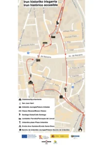
Le parcours historique accessible de la ville d’Irun est composé de 10 points d’intérêt emblématiques : l’hôtel de ville, la place San Juan, la colonne San Juan Harri, le palais Arbelaitz, le Musée romain Oiasso, la rue Santiago, l’église de Santa María del Juncal, la chapelle Santa Elena, la place Urdanibia et l’ancien hôpital des pèlerins.
Cet itinéraire circulaire de 2,1 km commence sous les arcades de l’hôtel de ville, place San Juan. Puis, en laissant l’hôtel de ville derrière nous, nous longeons le côté droit de la place jusqu’à la colonne San Juan Harri. Nous contournons ensuite la bibliothèque et nous traversons la place Almudena Grandes jusqu’à une aire de jeux et tournons à droite jusqu’au passage piéton de la rue Iglesia, afin d’avoir une excellente vue sur le palais Arbelaitz. Nous traversons la rue Iglesia, nous contournons le Palais et nous atteignons le Musée romain Oiasso, situé rue Escuelas. L’itinéraire se poursuit en descendant la rue Escuelas jusqu’à la rue Santiago. Nous empruntons la rue Santiago par le trottoir côté impair de la rue et revenons par le trottoir côté pair. Nous traversons la rue del Juncal et nous nous retrouvons sur une place triangulaire : nous sommes au sommet du triangle et à la base se trouve l’accès à l’église d’El Juncal. Nous retournons rue del Juncal et marchons du côté impair jusqu’à la Place Urdanibia. Après avoir visité la Place Urdanibia, nous continuons sur le trottoir côté pair de la rue Santa Elena jusqu’à la rue de la Ermita, où nous tournons à droite pour voir l’extérieur de la Chapelle Santa Elena. À ce stade, nous revenons sur nos pas par les rues Ermita et Santa Elena jusqu’à la Place Urdanibia, que nous laissons sur notre droite. Sur la gauche se trouve l’ancien hôpital des pèlerins. Nous tournons à droite pour contourner la Place Urdanibia et remontons vers la place San Juan, en passant par la rue Larretxipi, la rue Jesús et l’ascenseur public de la rue Jesús.
Informations sur les lignes et les horaires : https://ekialdebus.eus/es/lineas-diurnas/
Informations sur les lignes et les horaires : https://auif.es/ et sur l’APP IrunBus (https://www.irun.org/es/movilidad-sostenible/transporte-publico/app-irunbus).
Informations sur les horaires de la ligne 31 Hendaye – Irun : https://itineraires.txiktxak.fr/fr/horaires/TXIK-TXAK-Sud/Bus/ligne/31/direction/OUTWARD/31#
Informations sur les lignes et les horaires : https://laburundesa.com/
https://maps.app.goo.gl/qgg5nrENAvyu6gjy8
Les taxis sont exploités par Radio TAXI Bidasoa, qui dispose de véhicules adaptés. Ils doivent être réservés à l’avance en appelant le +34 943 633 303.
Emplacement Parking Plaza San Juan Telpark by Empark.
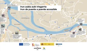
Nous nous promenons, d’un pont à l’autre, le long des rives du fleuve Bidasoa et nous découvrons sept points de vue différents sur notre histoire. Une frontière qui nous relie. Notre paix et notre protection. Notre chère Oiasso… Notre fleuve, symbole de l’effort pour aller de l’avant. Une myriade de possibilités.
Cet itinéraire de 3 kilomètres est linéaire et ne présente pratiquement aucun dénivelé. Il longe le fleuve, entre les ponts internationaux de Saint-Jacques et de Béhobie. On peut commencer le parcours dans l’une ou l’autre ces deux zones. L’itinéraire est composé de 7 points d’intérêt : les eaux de la Bidasoa, le stade Gal, le port de Santiago Marinero, l’ancienne caserne Osinbiribil, l’Ile des Faisans, le premier pont de Béhobie et le Corps de Garde de la Bidasoa. Chaque point d’intérêt dispose d’un panneau descriptif comprenant un code QR pour un complément d’information.
Informations sur les lignes et les horaires : https://ekialdebus.eus/es/lineas-diurnas/
Informations sur les horaires de la ligne 31 Hendaye – Irun : https://itineraires.txiktxak.fr/fr/horaires/TXIK-TXAK-Sud/Bus/ligne/31/direction/OUTWARD/31#
Informations sur les lignes et les horaires sur https://auif.es/ et sur l’APP IrunBus (https://www.irun.org/es/movilidad-sostenible/transporte-publico/app-irunbus)
Attention ! L’accès au panneau “Eaux de la Bidasoa” comporte des marches.
Attention ! Sur plusieurs tronçons de l’itinéraire, la piste cyclable rejoint la zone piétonne. Des marches permettent d’accéder au panneau d’information du point d’intérêt “Eaux de la Bidasoa”.
L’URL vers laquelle tous les QR sont dirigés est la suivante : https://www.bidasoaturismo.com/panelesbidasoa/.
Attention ! L’accès au panneau du point d’intérêt “Eaux de la Bidasoa” se fait par des marches.
L’URL vers laquelle tous les QR sont dirigés est la suivante : https://www.bidasoaturismo.com/panelesbidasoa/.
L’URL vers laquelle tous les QR sont dirigés est la suivante : https://www.bidasoaturismo.com/panelesbidasoa/.
L’URL vers laquelle tous les QR sont dirigés est la suivante : https://www.bidasoaturismo.com/panelesbidasoa/.
La nécropole ou cimetière romain d’Oiasso se trouvait à l’intérieur de la chapelle médiévale de Santa Elena. Des urnes contenant des cendres ont été retrouvées ici, ainsi que des objets funéraires tels que des récipients en céramique, des acus crinalis (aiguilles en os pour tenir les cheveux) et des fibules, pour ne citer que quelques-unes des pièces trouvées. À l’intérieur, la chapelle abrite des collections d’objets remarquables qui témoignent du niveau de vie atteint par ses occupants, très proche de celui des villes romaines de la côte atlantique.
Outre les sépultures, les fondations de deux bâtiments, interprétés comme des mausolées, ont été localisées.
Au 10e siècle, une petite chapelle a été construite sur l’emplacement d’un des édifices romains; cette petite chapelle a été remplacée au 14e siècle par une autre église chrétienne. Elle a atteint ses dimensions actuelles au XVIe siècle. La chapelle est dédiée à la mère de Constantin, l’empereur qui, en 313, a autorisé la religion chrétienne. Hélène a été sanctifiée pour avoir découvert les vestiges de la croix de bois sur laquelle est mort Jésus de Nazareth.
Les visites de la Chapelle de Santa Elena sont guidées et organisées par le Musée Romain Oiasso.
https://maps.app.goo.gl/x2mMreHhxUBvXyaR9
Accessible en transport public adapté : train et bus.
Informations sur les lignes et les horaires :
https://ekialdebus.eus/es/lineas-diurnas/
Informations sur les lignes et les horaires sur https://auif.es/ et sur l’APP IrunBus (https://www.irun.org/es/movilidad-sostenible/transporte-publico/app-irunbus).
Informations sur les horaires de la ligne 31 Hendaye – Irun : https://itineraires.txiktxak.fr/fr/horaires/TXIK-TXAK-Sud/Bus/ligne/31/direction/OUTWARD/31#
Informations sur les lignes et les horaires : https://laburundesa.com/
L’arrêt de bus le plus proche est “Urdanibia Plaza”, à 300 m de la Chapelle.
https://maps.app.goo.gl/qgg5nrENAvyu6gjy8
Les taxis sont exploités par Radio TAXI Bidasoa, qui dispose de véhicules adaptés. Ils doivent être réservés à l’avance en appelant le +34 943 633 303.
Les parcours piétonniers entre les arrêts et la Chapelle sont libres de barrières architecturales.
La Chapelle Santa Elena ne dispose pas de parking visiteurs.
La place Urdanibia est située au cœur de la vieille ville. Elle est également connue sous le nom d’Alameda, Mosku, mais elle s’est aussi appelée Plaza de la Feria et Plaza del Juego de Pelota parce que l’ancien fronton de pelote y était situé.
La place est présidée par l’Hôpital, construit au milieu du XVIIe siècle sous le patronage de l’Immaculée Conception et grâce à la donation testamentaire du général Sancho de Urdanibia y Topalda. Ce bâtiment rectangulaire de trois étages, séparés par des plate-bandes, présente sur sa façade principale une statue de la Vierge Marie ; au-dessus du fronton qui la surmonte, on distingue les armoiries de la famille Urdanibia.
Lorsque le nouvel hôpital fut construit à proximité, l’ancien hôpital cessa de fonctionner au début du XXe siècle. Il fut ensuite utilisé à diverses fins culturelles jusqu’à ce que, après la restauration financée par le Gouvernement Basque vers 1985, il soit destiné à l’enseignement de l’euskara.
Cette place, en plus d’accueillir le marché du samedi, où sont vendus tous types de produits, est le lieu de nombreuses animations festives et culturelles importantes.
Flâner dans les vieilles rues adjacentes est un plaisir qui nous ramène plusieurs siècles en arrière.
Accessible en transports publics adaptés : train et bus.
Notamment, les lignes :
Informations sur les lignes et les horaires :
Informations sur les lignes de bus et les horaires sur https://auif.es/ et dans l’APP IrunBus (https://www.irun.org/es/movilidad-sostenible/transporte-publico/app-irunbus)
Informations sur les horaires de la ligne 31 Hendaia – Irun : https://itineraires.txiktxak.fr/fr/horaires/TXIK-TXAK-Sud/Bus/ligne/31/direction/OUTWARD/31#
L’arrêt de bus le plus proche est “Urdanibia Plaza”.
https://maps.app.goo.gl/qgg5nrENAvyu6gjy8
Les taxis sont exploités par Radio TAXI Bidasoa, qui dispose de véhicules adaptés. Ils doivent être réservés à l’avance en appelant le +34 943 633 303.
Les parcours piétons entre les arrêts et la place sont libres de barrières architecturales.
Attention ! Place rectangulaire avec plusieurs accès
Attention ! Place très fréquentée.
La place San Juan Harria est située dans le quartier historique d’Irun, un point de rencontre pour les citoyens et les visiteurs.
L’histoire de la place de San Juan commence en 1564, lorsque le Conseil décide de placer une colonne de pierre, San Juan Harria, qui deviendra le symbole de l’indépendance d’Irun par rapport à Hondarribia, à l’endroit où les habitants se rassemblaient lorsqu’ils étaient appelés à prendre les armes.
Plus tard, lors de la construction de la nouvelle Maison du Conseil (1756-1763), l’espace public a été agrandi et la Plaza San Juan a été créée.
Accessible en transports publics adaptés : train et bus.
Notamment, les lignes :
Informations sur les lignes et les horaires :
Informations sur les lignes et les horaires : https://auif.es/ et sur l’APP IrunBus (https://www.irun.org/es/movilidad-sostenible/transporte-publico/app-irunbus).
Informations sur les horaires de la ligne 31 Hendaye – Irun : https://itineraires.txiktxak.fr/fr/horaires/TXIK-TXAK-Sud/Bus/ligne/31/direction/OUTWARD/31#
Informations sur les lignes et les horaires : https://laburundesa.com/
Les arrêts de bus les plus proches sont “Plaza San Juan”, “Fermín Calbetón”, “San Juan” sur l’avenue Paseo Colón, “Avenida Guipúzcoa 1” et “Avenida Guipúzcoa 6”.
https://maps.app.goo.gl/qgg5nrENAvyu6gjy8
Les taxis sont exploités par Radio TAXI Bidasoa, qui dispose de véhicules adaptés. Ils doivent être réservés à l’avance en appelant le +34 943 633 303.
Les voies piétonnes entre les arrêts et la place sont libres de barrières architecturales.
Attention ! Place carrée avec plusieurs accès.
Attention ! Cette place est généralement très fréque
Le Musée est la porte d’entrée à la ville romaine d’Oiasso. Inauguré en 2006, il rassemble les vestiges archéologiques de la période romaine qui ont été retrouvés dans la région grâce aux fouilles menées au cours des dernières décennies. Les recherches archéologiques ont permis de mettre au jour le port et ses entrepôts, les thermes, la nécropole et les exploitations minières des environs.
Les collections archéologiques, composées de matériaux organiques et de nombreux objets travaillés en cuir et en bois, nous parlent d’une implantation urbaine développée au cours des premiers siècles de notre ère grâce à l’activité du port, situé sur la route de l’Atlantique, et des mines situées à proximité.
Les collections sont organisées en trois salles : Impact, Port et Oiasso. La Salle Impact présente le monde autochtone vascon et les premiers contacts entre ce dernier et les colonisateurs romains. Dans la Salle Port, les vitrines contiennent des matériaux archéologiques qui nous renseignent sur le commerce et la pêche, les deux principales activités économiques liées au port. Enfin, la Salle Oiasso aborde les aspects quotidiens d’une ville romaine à l’époque du Haut-Empire : alimentation, habillement, écriture, loisirs et religion.
Bientôt, les visiteurs pourront découvrir le site archéologique des thermes romains d’Oiasso, qui s’ajoutera aux visites guidées organisées à la nécropole de Santa Elena et aux mines d’Irugurutzeta.
Le temps d’un week-end en juillet, le musée Oiasso et ses environs accueillent le festival Dies Oiassonis, qui recrée la vie quotidienne, la gastronomie, la musique et le théâtre de l’époque romaine.
https://maps.app.goo.gl/5wrMG5gQSpVeQi7J9
Accessible en transport public adapté : train et bus.
Notamment, les lignes :
Informations sur les lignes et les horaires :
Informations sur les lignes et les horaires : https://auif.es/ et sur l’APP IrunBus (https://www.irun.org/es/movilidad-sostenible/transporte-publico/app-irunbus).
Informations sur les horaires de la ligne 31 Hendaye – Irun : https://itineraires.txiktxak.fr/fr/horaires/TXIK-TXAK-Sud/Bus/ligne/31/direction/OUTWARD/31#
Informations sur les lignes et les horaires : https://laburundesa.com/
Les arrêts de bus les plus proches sont “Plaza San Juan”, “Fermín Calbetón”, “San Juan” sur l’avenue Paseo Colón, “Avenida Guipúzcoa 1” et “Avenida Guipúzcoa 6”.
https://maps.app.goo.gl/qgg5nrENAvyu6gjy8
Les taxis sont exploités par Radio TAXI Bidasoa, qui dispose de véhicules adaptés. Ils doivent être réservés à l’avance en appelant le +34 943 633 303.
Les voies piétonnes entre les arrêts et le musée sont libres de barrières architecturales.
Le Musée ne dispose pas de parking visiteurs.
Les détenteurs de la carte européenne de stationnement peuvent se garer gratuitement pendant 24 heures sur les places de stationnement marquées PMR dans la rue.
Attention ! Dans l’une des salles de l’étage 2, le retour vers la rampe d’accès se fait par 5 marches. Les personnes en fauteuil roulant doivent revenir sur leurs pas pour éviter ces marches.
Attention ! Dans l’une des salles de l’étage 2, le retour vers la rampe d’accès se fait par 5 marches. Les personnes en fauteuil roulant doivent revenir sur leurs pas pour éviter ces marches.
Accessible en transport public adapté : train et bus.
Notamment, les lignes :
Informations sur les lignes et les horaires :
Informations sur les lignes et les horaires sur https://auif.es/ et sur l’APP IrunBus (https://www.irun.org/es/movilidad-sostenible/transporte-publico/app-irunbus).
Informations sur les horaires de la ligne 31 Hendaye – Irun : https://itineraires.txiktxak.fr/fr/horaires/TXIK-TXAK-Sud/Bus/ligne/31/direction/OUTWARD/31#
Informations sur les lignes et les horaires : https://laburundesa.com/
Les arrêts de bus les plus proches sont “Plaza San Juan”, “Fermín Calbetón”, “San Juan” sur l’avenue Paseo Colón, “Avenida Guipúzcoa 1” et “Avenida Guipúzcoa 6”.
https://maps.app.goo.gl/4vrzWdzyS4ohTRqKA?g_st=im
Les parcours piétonniers entre les arrêts et l’Office du Tourisme sont libres de barrières architecturales.
Les chiens d’assistance (chiens-guides, chiens d’assistance, chiens d’alerte médicale, chiens pour personnes autistes, chiens d’assistance pour personnes à mobilité réduite, etc.) sont les bienvenus et ce gratuitement, conformément à la loi 10/2007, du 29 juin, relative aux chiens d’assistance pour les personnes en situation de handicap.
Personnel d’accueil aux visiteurs disponible.
L’église d’El Juncal, située dans une zone marécageuse, est construite sur des pilotis en bois. Sa construction a commencé en 1508 et s’est achevée en 1606. La longue durée des travaux a déterminé les différents styles de l’église : outre les caractéristiques typiques du gothique tardif, d’autres éléments du “gothique basque” apparaissent aussi.
À l’extérieur, c’est une masse de pierre de taille, avec de lourds contreforts, dépourvue d’ornementation, à l’exception du portail baroque du XVIIe siècle et de plusieurs gargouilles gothiques qui se découpent sur le ciel, aujourd’hui difficiles à voir après la rénovation effectuée sur les avant-toits de l’édifice.
Il s’agit d’une église rectangulaire à trois nefs et une abside plate. La partie la plus ancienne est l’abside, où l’on peut observer des éléments gothiques sur les colonnes adossées aux murs.
Des voûtes, appuyées sur des colonnes classiques, il ne reste que celles de l’abside et du chœur, les autres ayant été remplacées au cours de ce siècle. Le retable baroque du maître-autel a été conçu par Bernabé Cordero de Madrid, et les sculptures ont été réalisées par Juan Bascardo, sculpteur navarrais, au milieu du XVIIe siècle. La dorure n’a été réalisée qu’un siècle plus tard.
Le retable est présidé par une sculpture gothique de la Vierge de Juncal, la plus ancienne de Gipuzkoa.
Accessible en transports publics adaptés : train et bus.
Par exemple, les lignes :
Informations sur les lignes et les horaires : https://ekialdebus.eus/es/lineas-diurnas/
Informations sur les lignes de bus et les horaires sur https://auif.es/ et dans l’APP IrunBus (https://www.irun.org/es/movilidad-sostenible/transporte-publico/app-irunbus)
Informations sur les horaires de la ligne 31 Hendaia – Irun : https://itineraires.txiktxak.fr/fr/horaires/TXIK-TXAK-Sud/Bus/ligne/31/direction/OUTWARD/31#
Informations sur les lignes et les horaires : https://laburundesa.com/
Les arrêts de bus les plus proches sont “Plaza San Juan”, “Fermín Calbetón”, “San Juan” sur Paseo Colón, “Avenida Guipúzcoa 1” et “Avenida Guipúzcoa 6”.
https://maps.app.goo.gl/qgg5nrENAvyu6gjy8
Les taxis sont exploités par Radio TAXI Bidasoa, qui dispose de véhicules adaptés. Ils doivent être réservés à l’avance en appelant le +34 943 633 303.
Les parcours piétonniers entre les arrêts et l’église du Juncal sont libres de barrières architecturales.
https://www.bidasoaturismo.com/como-llegar/
Attention ! La tour n’est pas accessible aux personnes en fauteuil roulant et aux personnes à mobilité réduite.
L’hôtel de ville d’Irun, comme de nombreux hôtels de ville en Gipuzkoa, date du XVIIIe siècle et a été construit dans le style baroque, selon un courant artistique très répandu en Europe à l’époque. Il s’agit d’un bel édifice situé sur la place San Juan Harria, conçu par Felipe Crame, commandant du génie de Saint-Sébastien, dont le profil est représenté dans un médaillon sur le linteau de la porte centrale. La façade principale est en pierre de taille en bossage au rez-de-chaussée et aux angles, surmontée d’une corniche en pierre sur laquelle court une balustrade avec un grand blason sculpté dans la pierre calcaire.
Au rez-de-chaussée, une colonnade à cinq arcades mène à l’intérieur de l’édifice ; des effigies couronnées apparaissent au-dessus de chacune des arcades. Au premier étage, cinq portes à fronton s’ouvrent sur un grand balcon filant soutenu par des encorbellements. À l’intérieur, un grand escalier a été construit en 1903 pour célébrer les fêtes basques. Dans les différents locaux municipaux, on peut admirer des tableaux de Zuloaga, Darío de Regoyos, Salaberria, Salís, Bienabe Artía, Montes Iturrioz, Albizu, Gracenea, Mentxu Gal et d’autres.
Les visites de l’hôtel de ville sont guidées. Vérifiez les dates et horaires auprès de l’Office de Tourisme.
Accessible en transport public adapté : train et bus.
Informations sur les lignes et les horaires : https://ekialdebus.eus/es/lineas-diurnas/
Informations sur les lignes et les horaires : https://auif.es/ et sur l’APP IrunBus (https://www.irun.org/es/movilidad-sostenible/transporte-publico/app-irunbus).
Informations sur les horaires de la ligne 31 Hendaye – Irun : https://itineraires.txiktxak.fr/fr/horaires/TXIK-TXAK-Sud/Bus/ligne/31/direction/OUTWARD/31#
Informations sur les lignes et les horaires : https://laburundesa.com/
Les arrêts de bus les plus proches sont “Plaza San Juan”, “Fermín Calbetón”, “San Juan” sur l’avenue Paseo Colón, “Avenida Guipúzcoa 1” et “Avenida Guipúzcoa 6”.
https://maps.app.goo.gl/qgg5nrENAvyu6gjy8
Les taxis sont exploités par Radio TAXI Bidasoa, qui dispose de véhicules adaptés. Ils doivent être réservés à l’avance en appelant le +34 943 633 303.
Les parcours piétonniers entre les arrêts et l’hôtel de ville sont libres de barrières architecturales.
L’hôtel de ville ne dispose pas d’un parking visiteurs.
The accessible historical tour of the city of Irun includes 10 points of interest: the Town Hall, San Juan square, San Juan Harri Column, Arbelaitz Palace, Oiasso Roman Museum, Santiago Street, the Church of Santa María del Juncal, the Chapel of Santa Elena, Urdanibia Square and the old pilgrims’ hospital.
We start this 2.1 km circular route under the arches of the Town Hall in San Juan square. Then, leaving the Town Hall behind us, we walk along the right-hand side of the square until we reach the San Juan Harri column. Then we go round the library, we cross Almudena Grandes’ square up to a children’s playground and turn right towards the pedestrian crossing on Iglesia street: from this point we have excellent views of the Arbelaitz Palace. Then we cross to the other side of Iglesia street, we go around the Palace and arrive at the Oiasso Roman Museum on Escuelas street. The route continues down Escuelas street to Santiago street. We walk along the side with the odd-numbered houses on Calle Santiago and return along the even-numbered houses. We then cross to the other side of Juncal street and find ourselves in a square in the shape of a triangle. We are at the apex of the triangle: at the base we see the accessible entrance to the church, Iglesia del Juncal. We return to Juncal street and walk along the side with the odd numbers until we reach Plaza Urdanibia square. After visiting Plaza Urdanibia, we continue along the even numbers on Santa Elena street until we reach Ermita street, where we turn right to see the outside of Santa Elena Chapel. At this point, we retrace our steps along Ermita and Santa Elena streets until we reach Plaza Urdanibia, which we leave on our right. On the left, we discover the old pilgrims’ hospital. We then turn right towards Plaza Urdanibia and start our return journey towards San Juan square, up Larretxipi street, Jesús street and the public elevator on Jesús street.
https://maps.app.goo.gl/dSNu2zh2SjVJMRk17
Information on lines and timetables: https://ekialdebus.eus/es/lineas-diurnas/
Information on lines and timetables at https://auif.es/ and in the IrunBus APP (https://www.irun.org/es/movilidad-sostenible/transporte-publico/app-irunbus)
Timetable information for line 31 Hendaia – Irun: https://itineraires.txiktxak.fr/fr/horaires/TXIK-TXAK-Sud/Bus/ligne/31/direction/OUTWARD/31#
Information on lines and timetables: https://laburundesa.com/
Cabs are operated by Radio TAXI Bidasoa, which has adapted vehicles. They must be booked in advance via their website or by telephone: +34 943 633 303.
Parking Plaza San Juan Telpark by Empark.
We walk from bridge to bridge along the banks of the Bidasoa river and discover seven different perspectives on our history. A border that unites. Our peace and our protection. Our beloved Oiasso… Our river, reflections to move forward. A wealth of possibilities!
This 3-kilometre route is linear and practically flat. It goes along the river Bidasoa, between the international bridges of Santiago and Behobia. It is possible to start the route from one or the other. The path has 7 points of interest: the Bidasoa waters, the Gal Stadium, Santiago Marinero, the former Osinbiribil barracks, Pheasant Island, the first bridge of Behobia and the Bidasoa Guard House. Each point of interest features an information panel completed with QR codes.
Information on lines and timetables: https://ekialdebus.eus/es/lineas-diurnas/
Timetable information for line 31 Hendaia – Irun: https://itineraires.txiktxak.fr/fr/horaires/TXIK-TXAK-Sud/Bus/ligne/31/direction/OUTWARD/31#
Information on city bus lines and schedules at https://auif.es/ and on the IrunBus APP (https://www.irun.org/es/movilidad-sostenible/transporte-publico/app-irunbus)
Attention! There are steps up to the panel “Bidasoa waters” .
Warning! In several sections of the route, the cycle lane joins the pedestrian zone. There are steps to access the information panel ‘Bidasoa waters’.
Attention! Access to the panel ‘Bidasoa waters’ is via steps.
URL to which all the QR codes are directed: https://www.bidasoaturismo.com/panelesbidasoa/
URL to which all the QR codes are directed: https://www.bidasoaturismo.com/panelesbidasoa/
URL to which all the QR codes are directed: https://www.bidasoaturismo.com/panelesbidasoa/
The necropolis or Roman cemetery of Oiasso was discovered inside the medieval Chapel of Santa Elena. Urns containing ashes have been found along with funerary objects such as ceramic pots, acus crinalis or bone hairpins and fibulae, to name but a few of the pieces. The necropolis houses collections of outstanding objects that speak of the standard of living of its occupants, very much in tune with the urban environments of the Roman cities on the Atlantic coast.
Along with burial sites, the foundations of two buildings, believed to be mausoleums, have also been located.
In the 10th century, a small church was built on one of the Roman buildings; this small church was replaced in the 14th century by another Christian church. In the 16th century it reached its present dimensions. The chapel is dedicated to the mother of Constantine, the emperor who authorised the Christian religion in the year 313. Helena was sanctified for having discovered the remains of the wooden cross on which Jesus of Nazareth died.
Visits to the Chapel of Santa Elena are guided and organized by the Oiasso Roman Museum.
https://maps.app.goo.gl/x2mMreHhxUBvXyaR9
Accessible by adapted public transport: trains and buses.
Information on lines and timetables: https://ekialdebus.eus/es/lineas-diurnas/
Information on city bus lines and timetables at https://auif.es/ and in the IrunBus APP (https://www.irun.org/es/movilidad-sostenible/transporte-publico/app-irunbus).
Timetable information for line 31 Hendaia – Irun: https://itineraires.txiktxak.fr/fr/horaires/TXIK-TXAK-Sud/Bus/ligne/31/direction/OUTWARD/31#
Timetable information: https://laburundesa.com/
The nearest bus stop is “Urdanibia Plaza”, 300 m from the Chapel.
https://maps.app.goo.gl/qgg5nrENAvyu6gjy8
Cabs are operated by Radio TAXI Bidasoa, which has adapted vehicles. They must be booked in advance via their website or by telephone: +34 943 633 303.
The pedestrian routes between the stops and the Town Hall are free of architectural barriers.
The Santa Elena Chapel does not have a car park for visitors.
Urdanibia Square (Plaza Urdanibia) is located in the heart of the city’s old town. It is also known as the Alameda, Mosku, and was formerly the Plaza de la Feria y Juego de Pelota because the old pelota court was located there.
The square is dominated by the Hospital de la Purísima Concepción, which was built in the mid-17th century thanks to a bequest in the will of General Sancho de Urdanibia y Topalda. This three-storey rectangular building, separated by panels, has a sculpture of the Virgin on its main facade; above the pediment stands the coat of arms of the Urdanibia family.
At the beginning of the 20th century, the new hospital was built nearby and the old one ceased to function. It was then used for various cultural purposes until, after the restoration carried out by the Basque Government around 1985, it was dedicated to the teaching of the Basque language.
As well as hosting a lively market selling all kinds of products on Saturdays, this square is also a venue for many festive and cultural activities.
Walking through the old neighbouring streets is a pleasure that takes us back several centuries in time.
https://maps.app.goo.gl/tWAyEJTX3U7aMgjL7?g_st=im
https://maps.app.goo.gl/dSNu2zh2SjVJMRk17
Accessible by adapted public transport: trains and buses.
Information on lines and timetables: https://ekialdebus.eus/es/lineas-diurnas/
Information on city bus lines and timetables at https://auif.es/ and in the IrunBus APP (https://www.irun.org/es/movilidad-sostenible/transporte-publico/app-irunbus).
Timetable information for line 31 Hendaia – Irun: https://itineraires.txiktxak.fr/fr/horaires/TXIK-TXAK-Sud/Bus/ligne/31/direction/OUTWARD/31#
The nearest bus stop is “Urdanibia Plaza”.
https://maps.app.goo.gl/qgg5nrENAvyu6gjy8
Holders of the European parking card can park free of charge for 24 hours at a time in parking spaces marked PMR on the street.
The pedestrian routes from the car parks to City Hall are accessible to wheelchair users.
Attention! Rectangular square with several points of access.
Warning! The square is usually crowded.
The San Juan Harria Square is located in the historic centre of Irun, a meeting point for citizens and visitors.
The history of San Juan square begins in 1564, when the Council agrees to place a stone column, San Juan Harria, which became the symbol of the independence of Irun from Hondarribia. It was the place where people met when they were called to arms.
Later on, after the construction of the new Town House in 1756-1763, the public space was extended and San Juan Square was created.
Accessible by adapted public transport: trains and buses.
Information on lines and timetables: https://ekialdebus.eus/es/lineas-diurnas/
Information on city bus lines and timetables at https://auif.es/ and in the IrunBus APP (https://www.irun.org/es/movilidad-sostenible/transporte-publico/app-irunbus).
Timetable information for line 31 Hendaia – Irun: https://itineraires.txiktxak.fr/fr/horaires/TXIK-TXAK-Sud/Bus/ligne/31/direction/OUTWARD/31#
Information on lines and timetables: https://laburundesa.com/
The nearest bus stops are “Plaza San Juan”, “Fermín Calbetón”, “San Juan” on Paseo Colón, “Avenida Guipúzcoa 1” and “Avenida Guipúzcoa 6”.
https://maps.app.goo.gl/qgg5nrENAvyu6gjy8
Cabs are operated by Radio TAXI Bidasoa , which has adapted vehicles. They must be booked in advance via their website or by telephone: +34 943 633 303.
The pedestrian routes between the stops and the square are free of architectural barriers.
Attention! Square-shaped space with several access points.
Attention! This square is usually crowded.
The Museum is the gateway to the Roman city of Oiasso. Inaugurated in 2006, it brings together the most significant archaeological remains from the Roman era that have been recovered in the area through excavations carried out in recent decades. Archaeological research has identified the port and its warehouses, the thermal baths, the necropolis and the mining sites in the area.
The archaeological collections, which include organic materials and objects made of leather and wood, tell us about an urban settlement developed during the first centuries of our era thanks to the activity of its port, located on the Atlantic route, and the nearby mines.
The collections are organized in three halls: Impact, Port and Oiasso. The Impact Hall presents the life of Vascon natives and their first contacts with Roman colonizers. In the Port Hall, the display cases contain archaeological materials that tell us about trade and fishing, the two main economic activities associated with the port. Finally, the Oiasso Hall speaks of the everyday aspects of a Roman city of High Imperial period: diet, clothing, writing, leisure or religion.
Soon, visitors will be able to visit the archaeological site of the Roman baths of Oiasso, which will be added to the guided tours around the necropolis of Santa Elena and the mines of Irugurutzeta.
In July, the Oiasso museum and its surroundings become the stage of Dies Oiassonis, a week-end festival which recreates everyday life, gastronomy, music or theatre in Roman times.
https://maps.app.goo.gl/5wrMG5gQSpVeQi7J9
Accessible by adapted public transport: trains and buses.
Information on lines and timetables: https://ekialdebus.eus/es/lineas-diurnas/
Information on city bus lines and timetables at https://auif.es/
and in the IrunBus APP (https://www.irun.org/es/movilidad-sostenible/transporte-publico/app-irunbus)
Timetable information for line 31 Hendaia – Irun: https://itineraires.txiktxak.fr/fr/horaires/TXIK-TXAK-Sud/Bus/ligne/31/direction/OUTWARD/31#
Information on lines and timetables: https://laburundesa.com/
The nearest bus stops are “Plaza San Juan”, “Fermín Calbetón”, “San Juan” on Paseo Colón, “Avenida Guipúzcoa 1” and “Avenida Guipúzcoa 6”.
https://maps.app.goo.gl/qgg5nrENAvyu6gjy8
Cabs are operated by Radio TAXI Bidasoa , which has adapted vehicles. They must be booked in advance via their website or by telephone: +34 943 633 303.
The pedestrian routes between the stops and the Museum are free of architectural barriers.
The museum does not have a car park for visitors.
Attention! One of the rooms on the second floor has 5 steps to return to the ramps area. Wheelchair users should turn back to avoid steps.
Attention! One of the rooms on the second floor has 5 steps to return to the ramps area. Wheelchair users should turn back to avoid steps.
Accessible by adapted public transport: trains and buses.
Information on lines and timetables: https://ekialdebus.eus/es/lineas-diurnas/
Information on city bus lines and timetables at https://auif.es/ and in the IrunBus APP (https://www.irun.org/es/movilidad-sostenible/transporte-publico/app-irunbus)
Timetable information for line 31 Hendaia – Irun: https://itineraires.txiktxak.fr/fr/horaires/TXIK-TXAK-Sud/Bus/ligne/31/direction/OUTWARD/31#
Information on lines and timetables: https://laburundesa.com/
The nearest bus stops are “Plaza San Juan”, “Fermín Calbetón”, “San Juan” on Paseo Colón, “Avenida Guipúzcoa 1” and “Avenida Guipúzcoa 6”.
https://maps.app.goo.gl/4vrzWdzyS4ohTRqKA?g_st=im
The pedestrian routes between the stops and the Tourist Office are free of architectural barriers.
Assistance dogs (guide dogs, signal dogs, medical alert dogs, dogs for people with autism, assistance dogs for people with reduced mobility, etc.) are welcome and free of charge, in accordance with Law 10/2007, of June 29, 2007, on Assistance Dogs for People with Disabilities.
Staff available for visitors.
The church of El Juncal, located in a marshy area, is built on wooden piles. Its construction began in 1508 and finished in 1606. The lengthy duration of the works determined the different styles of the church, which includes elements from the late Gothic period to features of “Basque Gothic” style.
On the outside, it is a mass of ashlar stone, with heavy buttresses, devoid of ornamentation, except for the 17th century Baroque facade and several Gothic gargoyles. These architectural elements are now difficult to see after the renovation on the roof eaves.
The church is a rectangular building with three naves and a flat apse. The oldest part is the apse, with Gothic features appearing on the columns attached to the walls.
The apse and choir vaults, supported by classical columns, are the original vaults, the rest having been replaced in this century. The Baroque altarpiece was designed by Bernabé Cordero de Madrid, and the sculptures were made by Juan Bascardo, a sculptor from Navarre, in the mid-17th century. The gilding was not applied until a century later.
Presiding over the altarpiece is a Gothic sculpture of the Virgin of Juncal, the oldest in Gipuzkoa.
Accessible by adapted public transport: trains and buses.
Information on lines and timetables: https://ekialdebus.eus/es/lineas-diurnas/
Information on city bus lines and timetables at https://auif.es/ and in the IrunBus APP (https://www.irun.org/es/movilidad-sostenible/transporte-publico/app-irunbus).
Timetable information for line 31 Hendaia – Irun: https://itineraires.txiktxak.fr/fr/horaires/TXIK-TXAK-Sud/Bus/ligne/31/direction/OUTWARD/31#
Information on lines and timetables: https://laburundesa.com/
The nearest bus stops are “Plaza San Juan”, “Fermín Calbetón”, “San Juan” on Paseo Colón, “Avenida Guipúzcoa 1” and “Avenida Guipúzcoa 6”.
https://maps.app.goo.gl/qgg5nrENAvyu6gjy8
Cabs are operated by Radio TAXI Bidasoa, which has adapted vehicles. They must be booked in advance via the website or by telephone: +34 943 633 303.
The pedestrian routes between the stops and the Juncal Church are free of architectural barriers.
Attention! The tower is not accessible to wheelchair users and persons with reduced mobility.
Irun Town Hall, like many other town halls in Gipuzkoa, dates back to the 18th century and was built in the Baroque style, a widespread artistic trend in Europe at the time. It is a handsome building located in San Juan square, designed by Felipe Crame, commander of the San Sebastian Engineers, whose profile is depicted in a medallion on the lintel of the central door. The main facade is of ashlar stone with bosses on the ground floor and corners, topped with a stone cornice on which there is a balustrade featuring a large coat-of-arms carved into the limestone.
On the ground floor, a five-arched colonnade leads into the building; crowned effigies appear above each arch. On the first floor, five pedimented doors open onto a large running balcony supported by corbels. Inside, a grand staircase was built in 1903 to celebrate Basque festivals. Paintings by Zuloaga, Darío de Regoyos, Salaberria, Salís, Bienabe Artía, Montes Iturrioz, Albizu, Gracenea, Mentxu Gal and others decorate the municipal rooms.
Visits to the Town Hall are guided. Check dates and times at the Tourist Office.
Accessible by adapted public transport: trains and buses.
Information on lines and timetables: https://ekialdebus.eus/es/lineas-diurnas/
Information on lines and timetables at https://auif.es/ and in the IrunBus APP (https://www.irun.org/es/movilidad-sostenible/transporte-publico/app-irunbus).
Timetable information for line 31 Hendaia – Irun: https://itineraires.txiktxak.fr/fr/horaires/TXIK-TXAK-Sud/Bus/ligne/31/direction/OUTWARD/31#
Information on line and timetable: https://laburundesa.com/
The nearest bus stops are “Plaza San Juan”, “Fermín Calbetón”, “San Juan” on Paseo Colón, “Avenida Guipúzcoa 1” and “Avenida Guipúzcoa 6”.
https://maps.app.goo.gl/qgg5nrENAvyu6gjy8
Cabs are operated by Radio TAXI Bidasoa, which has adapted vehicles. They must be booked in advance via the website or by telephone: +34 943 633 303.
The pedestrian routes between the stops and the Town Hall are free of architectural barriers.
The Town Hall does not have a car park for visitors.
Irungo hiriko ibilbide historiko irisgarria 10 gune interesgarrik osatzen dute: Udaletxea, San Juan plaza, San Juan Harria, Arbelaitz jauregia, Oiasso Erromatar Museoa, Santiago kalea, Junkaleko Ama Birjinaren parrokia, Ama Xantalen ermita, Urdanibia plaza eta erromesen ospitale zaharra.
Udaletxeko arkupeetan, San Juan plazan, hasiko dugu 2,1 km-ko ibilbide zirkular hau. Gero, udaletxea atzean utzita, plazaren eskuinaldetik joango gara San Juan Harrira iritsi arte. Ondoren, liburutegia inguratu eta atzean utzi ondoren, Almudena Grande plaza zeharkatuko dugu haur parke batera iritsi arte, eta eskuinera egingo dugu Eliza kaleko oinezkoentzako pasabideraino: Arbelaitz jauregiaren ikuspegi bikaina dugu handik. Ondoren, Eliza kalearen beste aldera pasako gara, Jauregia inguratu eta Oiasso Erromatar Museora iritsiko gara, Eskoleta kalean. Ibilbideak Eskoleta kaletik behera jarraitzen du Santiago kaleraino. Santiago kalea zenbaki bakoitien espaloitik igaroko dugu eta zenbaki bikoitien espaloitik itzuliko gara. Junkal kalearen beste aldera igaro ondoren, plaza batera iritsiko gara. Triangelu isoszelearen forma du. Triangeluaren erpinean gaude, eta, oinarrian, Junkal elizarako sarbide irisgarria dago. Junkal kalera itzuliko gara eta zenbaki bakoitien aldetik joango gara Urdanibia plazaraino. Urdanibia plaza bisitatu ondoren, Santa Elena kaleko zenbaki bikoitien espaloitik jarraituko dugu Ermita kaleraino. Han, eskuinera egingo dugu Santa Elena ermitaren kanpoaldea ikusteko. Puntu horretan, egindako bidetik itzuliko gara Ermita eta Santa Elena kaleetatik Urdanibia plazaraino, eta eskuinetara utziko dugu. Ezkerrean, erromesen ospitale zaharra topatuko dugu. Eskuinera biratuko dugu Urdanibia plaza inguratu eta San Juan Plazara itzultzeko, Larretxipi kaletik eta Jesus kaletik gora, Jesus kaleko igogailu publikora.
Linea eta ordutegiei buruzko informazioa: https://ekialdebus.eus/es/lineas-diurnas/
Hiri autobusen lineei eta ordutegiei buruzko informazioa https://auif.es/ helbidean eta IrunBus APPan (https://www.irun.org/es/movilidad-sostenible/transporte-publico/app-irunbus)
Hendaia – Irun 31. linearen ordutegiei buruzko informazioa: https://itineraires.txiktxak.fr/fr/horaires/TXIK-TXAK-Sud/Bus/ligne/31/direction/OUTWARD/31#
Linea eta ordutegiari buruzko informazioa: https://laburundesa.com/
Taxiak Radio TAXI Bidasoa konpainiak kudeatzen ditu, eta ibilgailu egokituak ditu. Aldez aurretik erreserbatu behar dira +34 943 633 303 telefonora deituta.
Kokapena San Juan plaza parkinga Telpark by Empark.
Zubiz zubi ibiliko gara Bidasoa ibaiaren ertzetik, eta gure historiaren zazpi ikuspuntu ezberdin aurkituko ditugu. Muga bat, lotzen duena. Gure bakea eta gure babesa. Gure Oiasso maitea… Gure ibaia, aurrera egiteko ahalegina islatzen duena. Aukera ugari.
3 kilometroko ibilbide hau lineala da eta ia ez du desnibelik. Ibaiaren ondoan dago, Santiagoko eta Behobiako nazioarteko zubien artean, eta bi eremu horietako edozeinetan has daiteke ibilbidea. Ibilbidea 7 interesgunek osatzen dute: Bidasoa ibaiko urak, Stadium Gal, Santiago Marinel auzoa, Osinbiribileko kuartel zaharra, Konpantzia edo Faisaien uhartea, Behobiako lehen zubia eta Bidasoko Guardia Gorputzaren eraikina. Interesgune bakoitzak informazio panel bat du, QR kodeekin osatua.
Linea eta ordutegiei buruzko informazioa: https://ekialdebus.eus/es/lineas-diurnas/
Hendaia – Irun 31. linearen ordutegiei buruzko informazioa: https://itineraires.txiktxak.fr/fr/horaires/TXIK-TXAK-Sud/Bus/ligne/31/direction/OUTWARD/31#
Hiri autobusen lineei eta ordutegiei buruzko informazioa https://auif.es/ helbidean eta IrunBus APPan (https://www.irun.org/es/movilidad-sostenible/transporte-publico/app-irunbus)
Erne! “Bidasoa ibaiko urak” interesguneko panelera iristeko eskailera mailak igo behar dira.
Erne! Ibilbidearen hainbat zatitan bidegorria eta oinezkoentzako gunea elkartzen dira. Eskailera mailak igo behar dira “Bidasoa ibaiko urak” interesguneko informazio panelera iristeko.
QR guztiek honako URL honetara eramango zaituzte: https://www.bidasoaturismo.com/panelesbidasoa/
Erne! “Bidasoa ibaiko urak” interesguneko panelera iristeko eskailera mailak igo behar dira.
QR guztiek honako URL honetara eramango zaituzte: https://www.bidasoaturismo.com/panelesbidasoa/
QR guztiek honako URL honetara eramango zaituzte: https://www.bidasoaturismo.com/panelesbidasoa/
QR guztiek honako URL honetara eramango zaituzte: https://www.bidasoaturismo.com/panelesbidasoa/
Erdi Aroko Ama Xantalen ermitaren barnean aurkitu zuten Oiassoko erromatar nekropolia edo hilerria. Zenbait ontzi aurkitu dira, barruan hautsekin, hileta ostilamenduekin batera, esate baterako, zeramikazko ontziak, acus crinalis edo ilerako hezurrezko orratzak, eta fibulak, aurkitutako piezetako batzuk aipatzearren. Objektu guztiz bikainen bildumak ditu barnean, okupatzaileek zuten bizi mailaren erakusgarri, Atlantikoaren bazterreko erromatar hirietako hiri giroen oso parekoak.
Hilobiekin batera bi eraikinen zimenduak aurkitu ziren, mausoleotzat hartu zirenak.
Ama Xantalen Ermitara bisita gidatuak egiten dira eta Oiasso Erromatar Museoak kudeatzen ditu.
https://maps.app.goo.gl/x2mMreHhxUBvXyaR9
Garraio publiko egokituan irits daiteke: trenez eta autobusez.
Honako linea hauek, esate baterako:
Linea eta ordutegiei buruzko informazioa: https://ekialdebus.eus/es/lineas-diurnas/
Hiri autobusen lineei eta ordutegiei buruzko informazioa https://auif.es/ helbidean eta IrunBus APPan (https://www.irun.org/es/movilidad-sostenible/transporte-publico/app-irunbus)
Hendaia – Irun 31. linearen ordutegiei buruzko informazioa:
Linea eta ordutegiari buruzko informazioa: https://laburundesa.com/
Hurbilen dagoen autobus geltokia “Urdanibia Plaza” da, Ermitatik 300 m-ra.
https://maps.app.goo.gl/qgg5nrENAvyu6gjy8
Taxiak Radio TAXI Bidasoa konpainiak kudeatzen ditu, eta ibilgailu egokituak ditu. Aldez aurretik erreserbatu behar dira +34 943 633 303 telefonora deituta.
Geltokien eta Ermitaren arteko oinezkoentzako ibilbideetan ez dago oztopo arkitektonikorik.
Ama Xantalen Ermitak ez du bisitarientzako aparkalekurik.
Hiriko alde zaharraren bihotzean dago Urdanibia plaza, eta Alameda eta Mosku izenez ere ezagutzen da. Azokaren plaza eta Pilota Jokoaren plaza izan zen lehen, bertan baitzegoen frontoi zaharra.
Plaza buruan Ospitalea zenaren eraikina dago. Ama Guztiz Garbiari eskainia da eta XVII. mendearen erdialdean eraiki zuten, Sancho de Urdanibia y Topalda jeneralak bere testamentuan utzitako donazioari esker. Oinplano angeluzuzena du eraikinak eta hiru solairu ditu, platabandez bereiziak. Ama Birjinaren irudia du fatxada nagusian. Irudia estaltzen duen frontoiaren gainean Urdanibiatarren armarria ikus daiteke.
Inguruan ospitale berria eraiki zutenean, aurrekoak funtzionatzeari utzi zion XX. mende hasieran. Orduz geroztik kultura arloko era askotako erabilerak eman zaizkio, 1985. urte aldera Eusko Jaurlaritzak berritu eta euskara irakasteko euskaltegi bihurtu zen arte.
Larunbatetan azoka egiten da plaza honetan eta era guztietako produktuak saltzen dituzte. Horrez gain, jai eta kultura jarduera garrantzitsu ugari egiten dira bertan.
Oso atsegina da plazaren inguruko kale zaharretan barrena ibiltzea, denboran hainbat mende atzera egin dugula ematen baitu.
Garraio publiko egokituan irits daiteke: trenez eta autobusez.
Honako linea hauek, esate baterako:
Linea eta ordutegiei buruzko informazioa: https://ekialdebus.eus/es/lineas-diurnas/
Hiri autobusen lineei eta ordutegiei buruzko informazioa https://auif.es/ helbidean eta IrunBus APPan (https://www.irun.org/es/movilidad-sostenible/transporte-publico/app-irunbus)
Hendaia – Irun 31. linearen ordutegiei buruzko informazioa: https://itineraires.txiktxak.fr/fr/horaires/TXIK-TXAK-Sud/Bus/ligne/31/direction/OUTWARD/31#
Hurbilen dagoen autobus geltokia “Urdanibia Plaza” da.
https://maps.app.goo.gl/qgg5nrENAvyu6gjy8
Taxiak Radio TAXI Bidasoa konpainiak kudeatzen ditu, eta ibilgailu egokituak ditu. Aldez aurretik erreserbatu behar dira +34 943 633 303 telefonora deituta.
Geltokien eta plazaren arteko oinezkoentzako ibilbideetan ez dago oztopo arkitektonikorik.
Europako aparkaleku txartel urdinaren jabeek mugikortasun urriko pertsonentzako markatutako plazetan aparka dezakete kalean, kosturik gabe, 24 orduz jarraian.
Aparkalekuetatik plazara joateko oinezkoentzako ibilbideak irisgarriak dira aulki gurpildunak erabiltzen dituzten pertsonentzat.
Erne! plaza angeluzuzena da eta hainbat sarrera ditu.
Erne! Jende asko pilatzen da bertan.
San Juan Harria plaza Irungo hirigune historikoan dago, herritarren eta bisitarien topagunean.
San Juan plazaren historia 1564an hasi zen, kontzejuak harrizko zutabe bat jartzea erabaki zuenean, San Juan Harria, eta Irunek Hondarribiarekiko lortutako independentziaren sinbolo bihurtu zen, herritarrak armak hartzera deitzen zituztenean elkartzen ziren tokian.
Ondoren, 1756-1763 artean kontzeju etxe berria eraiki zutenean, aukera baliatu zuten espazio publikoa handitzeko eta San Juan plaza bera sortzeko.
Garraio publiko egokituan irits daiteke: trenez eta autobusez.
Honako linea hauek, esate baterako:
Linea eta ordutegiei buruzko informazioa: https://ekialdebus.eus/es/lineas-diurnas/
Hiri autobusen lineei eta ordutegiei buruzko informazioa https://auif.es/ helbidean eta IrunBus APPan (https://www.irun.org/es/movilidad-sostenible/transporte-publico/app-irunbus)
Hendaia – Irun 31. linearen ordutegiei buruzko informazioa: https://itineraires.txiktxak.fr/fr/horaires/TXIK-TXAK-Sud/Bus/ligne/31/direction/OUTWARD/31#
Linea eta ordutegiari buruzko informazioa: https://laburundesa.com/
Hurbilen dauden autobus geltokiak honako hauek dira: “San Juan plaza”, “Fermín Calbetón”, “San Juan” Colon Ibilbidean, “Gipuzkoa Etorbidea 1” eta “Gipuzkoa Etorbidea 6”.
https://maps.app.goo.gl/qgg5nrENAvyu6gjy8
Taxiak Radio TAXI Bidasoa konpainiak kudeatzen ditu, eta ibilgailu egokituak ditu. Aldez aurretik erreserbatu behar dira +34 943 633 303 telefonora deituta.
Geltokien eta plazaren arteko oinezkoentzako ibilbideetan ez dago oztopo arkitektonikorik.
Erne! plaza karratua da eta hainbat sarrera ditu.
Erne! Jende asko pilatzen da bertan.
Oiasso erromatar hirirako atea da museoa. 2006an inauguratu zen, eta erromatarren garaiko hondakin arkeologiko garrantzitsuenak biltzen ditu, azken hamarkadetan eremuan egindako indusketen bidez berreskuratu direnak. Ikerketa arkeologikoari esker, identifikatu ahal izan dira portua eta bertako biltegiak, termak, nekropolia eta inguruko meatze ustiategiak.
Bilduma arkeologikoek erakusten dute, haien artean material organikoak dira nagusi larruan eta zurean landutako objektuekin, ezarlekua gure aroko lehen mendeetan garatu zela portuak zuen jarduerari (ibilbide atlantikoan baitzegoen), eta inguruetako meatzeei esker.
Hiru gelatan antolatuak daude material bildumak: Erromatarren eragina, Portua eta Oiasso. Erromatarren eragina gelak baskoien mundu indigena erakusten du, bai eta haren eta erromatar kolonizatzaileen artean izandako lehen harremanak ere. Portua gelan, berriz, merkataritzaz eta arrantzaz hitz egiten diguten material arkeologikoak biltzen dituzte beira arasek, portuarekin loturiko bi jarduera ekonomiko nagusiak, hain zuzen ere. Azkenik, Oiasso gelak Goi Inperioaren garaiko erromatar hiri baten eguneroko alderdiez hitz egiten digu: dieta, jantziak, idazkera, aisia edo erlijioa.
Laster, Oiassoko terma erromatarren aztarnategi arkeologikoa ezagutzeko aukera izango dute bisitariek, Ama Xantalen nekropolira eta Irugurutzetako meategietara antolatzen diren bisita gidatuekin batera.
Uztailean, Oiasso museoa eta inguruak Dies Oiassonis jaialdiaren agertoki bihurtzen dira asteburu batez. Jaialdi horrek erromatarren garaiko eguneroko bizitza, gastronomia, musika edo antzerkia erakusten ditu.
https://maps.app.goo.gl/5wrMG5gQSpVeQi7J9
Garraio publiko egokituan irits daiteke: trenez eta autobusez.
Honako linea hauek, esate baterako:
Linea eta ordutegiei buruzko informazioa: https://ekialdebus.eus/es/lineas-diurnas/
Hiri autobusen lineei eta ordutegiei buruzko informazioa https://auif.es/ helbidean eta IrunBus APPan (https://www.irun.org/es/movilidad-sostenible/transporte-publico/app-irunbus)
Hendaia – Irun 31. linearen ordutegiei buruzko informazioa: https://itineraires.txiktxak.fr/fr/horaires/TXIK-TXAK-Sud/Bus/ligne/31/direction/OUTWARD/31#
Lineari eta ordutegiari buruzko informazioa: https://laburundesa.com/
Hurbilen dauden autobus geltokiak honako hauek dira: “San Juan plaza”, “Fermín Calbetón”, “San Juan” Colon Ibilbidean, “Gipuzkoa hiribidea 1” eta “Gipuzkoa hiribidea 6”.
https://maps.app.goo.gl/qgg5nrENAvyu6gjy8
Taxiak Radio TAXI Bidasoa konpainiak kudeatzen ditu, eta ibilgailu egokituak ditu. Aldez aurretik erreserbatu behar dira +34 943 633 303 telefonora deituta.
Geltokien eta Museoaren arteko oinezkoentzako ibilbideetan ez dago oztopo arkitektonikorik.
Museoak ez du bisitarientzako aparkalekurik.
Europako aparkaleku txartel urdinaren jabeek mugikortasun urriko pertsonentzako markatutako plazetan aparka dezakete kalean, kosturik gabe, 24 orduz jarraian.
Erne! 2. solairuko gela batean 5 eskailera maila daude arrapalen eremura itzultzeko. Aulki gurpildunak erabiltzen dituztenek etorritako bidetik itzuli beharko dute eskailera mailak saihesteko.
Erne! 2. solairuko gela batean 5 eskailera maila daude arrapalen eremura itzultzeko. Aulki gurpildunak erabiltzen dituztenek etorritako bidetik itzuli beharko dute eskailera mailak saihesteko.
Garraio publiko egokituan irits daiteke: Trenez eta autobusez.
Honako linea hauek, esate baterako:
Linea eta ordutegiei buruzko informazioa: https://ekialdebus.eus/es/lineas-diurnas/
Hiri autobusen lineei eta ordutegiei buruzko informazioa https://auif.es/ helbidean eta IrunBus APPan (https://www.irun.org/es/movilidad-sostenible/transporte-publico/app-irunbus)
Hendaia – Irun 31. linearen ordutegiei buruzko informazioa: https://itineraires.txiktxak.fr/fr/horaires/TXIK-TXAK-Sud/Bus/ligne/31/direction/OUTWARD/31#
Linea eta ordutegiari buruzko informazioa: https://laburundesa.com/
Hurbilen dauden autobus geltokiak honako hauek dira: “San Juan plaza”, “Fermín Calbetón”, “San Juan” Colon Ibilbidean, “Gipuzkoa hiribidea 1” eta “Gipuzkoa hiribidea 6”.
Geltokien eta Bulegoaren arteko oinezkoentzako ibilbideetan ez dago oztopo arkitektonikorik.
Laguntza txakurrak onartzen dira, gogo onez eta kosturik gabe (itsu txakurrak, seinalea, alerta medikokoa, autismoa duten pertsonenak, mugikortasun urriko pertsonentzako zerbitzua, etab.), Ahalmen Urrituentzako Laguntza Txakurrei buruzko ekainaren 29ko 10/2007 Legearen arabera.
Bisitariei arreta emateko langileak daude.
Junkal eliza zurezko piloteen gainean dago, padurako eremuan. 1508. urtean hasi ziren eraikitzen eta 1606an amaitu zuten. Eraikuntza lanek luze jo zutenez era askotako arte estiloak ageri dira tenplu honetan; beraz, molde gotikoaren azken aldiko ezaugarriekin batera “euskal gotikoaren” atalak ere baditu eraikinak.
Kanpoko aldetik harlanduzko eraikin handi eta ikusgarria da, horma bular edo kontrahorma sendoak dauzka, eta apaindura gutxi: XVII. mendeko portada barrokoa eta hainbat gargola gotiko zerua ebakitzen. Teilatu hegala berritzeko egin ziren obretan gargola gehienak estali egin zituzten eta gaur egun nekez ikusten dira.
Oin angeluzuzeneko eraikina da, hiru nabe eta burualde lauko absidea ditu. Parterik zaharrena absidearen ingurua da, eta bertan, hormari itsatsitako zutabeetan, molde gotikoko ezaugarriak nabari dira.
Zutabe klasikoek eusten diete gangei, baina absideko eta koruko gangak baino ez dira kontserbatu, XX. mendean aldatu egin baitzituzten gainerako guztiak. Aldare Nagusiko Erretaula Barrokoa Bernabe Corderok (Madrilgoa) diseinatu zuen eta bertako eskulturak, berriz, Juan Bazkardo eskultore nafarrak egin zituen XVII. mendearen erdialdean. Erretaulari hurrengo mendean eman zioten urre kolorea.
Erretaularen buruan Junkaleko Ama Birjinaren irudi gotikoa dago, Gipuzkoan ezagutzen den irudi zaharrena.
Garraio publiko egokituan irits daiteke: trenez eta autobusez.
Honako linea hauek, esate baterako:
Linea eta ordutegiei buruzko informazioa: https://ekialdebus.eus/es/lineas-diurnas/
Hiri autobusen lineei eta ordutegiei buruzko informazioa https://auif.es/ helbidean eta IrunBus APPan (https://www.irun.org/es/movilidad-sostenible/transporte-publico/app-irunbus)
Hendaia – Irun 31. linearen ordutegiei buruzko informazioa: https://itineraires.txiktxak.fr/fr/horaires/TXIK-TXAK-Sud/Bus/ligne/31/direction/OUTWARD/31#
Lineari eta ordutegiari buruzko informazioa: https://laburundesa.com/
Hurbilen dauden autobus geltokiak honako hauek dira: “San Juan plaza”, “Fermín Calbetón”, “San Juan” Colon Ibilbidean, “Gipuzkoa hiribidea 1” eta “Gipuzkoa hiribidea 6”.
https://maps.app.goo.gl/qgg5nrENAvyu6gjy8
Taxiak Radio TAXI Bidasoa konpainiak kudeatzen ditu, eta ibilgailu egokituak ditu. Aldez aurretik erreserbatu behar dira +34 943 633 303 telefonora deituta.
Geltokien eta Junkal Elizaren arteko oinezkoentzako ibilbideetan ez dago oztopo arkitektonikorik.
Erne! Dorrea ezin dute bisitatu aulki gurpilduna erabiltzen dutenek, ez eta mugikortasun urritua dutenek ere.
Irungo Udaletxea, Gipuzkoako Udaletxe gehienak bezala, XVIII. mendekoa da, eta barroko estiloan eraikia da, garai hartan Europan zabalduta zegoen korronte artistikoari jarraituz. Eraikin ederra da, eta San Juan Harria plazan dago. Felipe Crame Donostiako plazako ingeniari komandanteak egin zuen proiektua, eta haren profila ageri da ate nagusiaren gainaldean dagoen medailoian. Fatxada nagusia harlanduzkoa da eta kuxindurak ageri ditu beheko solairuan eta eskantzuetan; harrizko erlaitza du, eta haren gainean balaustrada bat, kareharriz eginiko armarri handiak zatitua.
Beheko solairuan bost arkuko arkupea du eraikinera sartzeko; arku bakoitzaren gainean irudi koroadunak ageri dira. Solairu nagusian balkoi jarraitu handia du, mentsuletan oinarritua, eta errematean frontoiak dituzten bost atek dute irteera balkoi horretara. Barrualdean eskailera handi bat du, 1903. urtean eraikia euskal jaiak zirela eta. Udal aretoetan banaturik margolan ederrak ikus daitezke, honako margolari hauenak, hain zuzen ere: Zuloaga, Dario de Regoyos, Salaberria, Salis, Bienabe Artia, Montes Iturrioz, Albizu, Gracenea, Mentxu Gal eta beste.
Udaletxera bisitak gidatuak dira. Kontsultatu datak eta ordutegiak Turismo Bulegoan.
Garraio publiko egokituan irits daiteke: trenez eta autobusez.
Honako linea hauek, esate baterako:
Linea eta ordutegiei buruzko informazioa: https://ekialdebus.eus/es/lineas-diurnas/
Hiri autobusen lineei eta ordutegiei buruzko informazioa https://auif.es/ helbidean eta IrunBus APPan (https://www.irun.org/es/movilidad-sostenible/transporte-publico/app-irunbus)
Hendaia – Irun 31. linearen ordutegiei buruzko informazioa: https://itineraires.txiktxak.fr/fr/horaires/TXIK-TXAK-Sud/Bus/ligne/31/direction/OUTWARD/31#
Lineari eta ordutegiari buruzko informazioa: https://laburundesa.com/
Hurbilen dauden autobus geltokiak honako hauek dira: “San Juan plaza”, “Fermín Calbetón”, “San Juan” Colon Ibilbidean, “Gipuzkoa hiribidea 1” eta “Gipuzkoa hiribidea 6”.
https://maps.app.goo.gl/qgg5nrENAvyu6gjy8
Taxiak Radio TAXI Bidasoa konpainiak kudeatzen ditu, eta ibilgailu egokituak ditu. Aldez aurretik erreserbatu behar dira +34 943 633 303 telefonora deituta.
Geltokien eta udaletxearen arteko oinezkoentzako ibilbideetan ez dago oztopo arkitektonikorik.
Udaletxeak ez du bisitarientzako aparkaleku propiorik.
El recorrido histórico accesible de la ciudad de Irun está integrado por 10 emblemáticos puntos de interés: el Ayuntamiento, la Plaza de San Juan, la Columna San Juan Harri, el Palacio Arbelaitz, el Museo Romano Oiasso, la calle Santiago, la Parroquia de Santa María del Juncal, la Ermita de Santa Elena, la Plaza Urdanibia y el antiguo hospital de peregrinos.
Iniciamos este recorrido circular de 2,1 km, en los arcos del Ayuntamiento en la Plaza de San Juan. Luego, dejando a nuestra espalda la Casa Consistorial, caminamos por el lado derecho de la plaza hasta llegar a la columna San Juan Harri. A continuación, rodeamos la biblioteca dejándola atrás, atravesamos la plaza Almudena Grande hasta un parque infantil y giramos a la derecha hasta el paso de peatones de la calle Iglesia: desde este punto tenemos excelentes vistas del Palacio Arbelaitz. Seguidamente, cruzamos al otro lado de la calle iglesia, bordeamos el Palacio y llegamos al Museo Romano Oiasso en la calle Escuelas. El recorrido continúa bajando por la calle Escuelas hasta la calle Santiago. Recorremos la calle Santiago por la acera de los números impares y volvemos por la acera de los números pares. Cruzamos al otro lado de la calle del Juncal y nos encontramos en una plaza que tiene forma de triángulo isósceles, estamos en el vértice del triángulo y en la base se encuentra el acceso accesible a la Iglesia del Juncal. Volvemos a la calle del Juncal y caminamos por el lado de los números impares hasta la plaza Urdanibia. Tras visitar la plaza Urdanibia, continuamos por la acera de los números pares de la calle Santa Elena hasta la Calle de la Ermita, donde giramos a la derecha para ver el exterior de la Ermita de Santa Elena. En este punto, volvemos sobre nuestros pasos por la calle de la Ermita y de Santa Elena hasta la Plaza Urdanibia que dejaremos a nuestra derecha. A la izquierda nos encontramos con el antiguo hospital de peregrinos. Giramos a la derecha para rodear la plaza Urdanibia e iniciar la vuelta a la Plaza de San Juan ascendiendo a través de la calle Larretxipi, la calle Jesús y el ascensor público de la Calle Jesús.
Información sobre líneas y horarios: https://ekialdebus.eus/es/lineas-diurnas/
Información sobre líneas y horarios de autobuses urbanos en https://auif.es/ y en la APP IrunBus (https://www.irun.org/es/movilidad-sostenible/transporte-publico/app-irunbus)
Información horarios de la línea 31 Hendaia – Irun: https://itineraires.txiktxak.fr/fr/horaires/TXIK-TXAK-Sud/Bus/ligne/31/direction/OUTWARD/31#
Información sobre línea y horario: https://laburundesa.com/
Los taxis están operados por Radio TAXI Bidasoa, que dispone de vehículos adaptados. Es necesario reservarlos con antelación a través del teléfono: +34 943 633 303.
Ubicación Parking Plaza San Juan Telpark by Empark.
Paseamos, de puente a puente, por la ribera del Bidasoa y descubrimos siete puntos de vista diferentes de nuestra historia. Una frontera, que une. Nuestra paz y nuestra protección. Nuestro querido Oiasso… Nuestro río, que refleja un esfuerzo por avanzar. Un gran caudal de posibilidades.
Esta ruta de 3 kilómetros es lineal y prácticamente sin desniveles. Se encuentra junto al río entre los puentes internacionales de Santiago y de Behobia, siendo posible iniciar el recorrido en cualquiera de esas 2 áreas. La ruta está integrada por 7 puntos de interés: las Aguas del Bidasoa, Stadium Gal, Santiago Marinero, antiguo Cuartel de Osinbiribil, Isla de los Faisanes, el primer puente de Behobia y el Cuerpo de Guardia del Bidasoa. Cada punto de interés tiene un panel informativo complementados con códigos QR.
Información sobre líneas y horarios: https://ekialdebus.eus/es/lineas-diurnas/
Información horarios de la línea 31 Hendaia – Irun: https://itineraires.txiktxak.fr/fr/horaires/TXIK-TXAK-Sud/Bus/ligne/31/direction/OUTWARD/31#
Información sobre líneas y horarios de autobuses urbanos en https://auif.es/ y en la APP IrunBus (https://www.irun.org/es/movilidad-sostenible/transporte-publico/app-irunbus)
¡Atención! El acceso al panel “Aguas del Bidasoa” tiene escalones.
¡Atención! En varios tramos del recorrido se juntan el carril bici con la zona peatonal. Hay escalones para acceder al panel informativo del punto de interés “Aguas del Bidasoa”.
La URL a la que dirigen todos los QR es https://www.bidasoaturismo.com/panelesbidasoa/
¡Atención! El acceso al panel del punto de interés “Aguas del Bidasoa” es a través de escalones.
La URL a la que dirigen todos los QR es https://www.bidasoaturismo.com/panelesbidasoa/
La URL a la que dirigen todos los QR es https://www.bidasoaturismo.com/panelesbidasoa/
La URL a la que dirigen todos los QR es https://www.bidasoaturismo.com/panelesbidasoa/
En el interior de la ermita medieval de Santa Elena se localizó la necrópolis o cementerio romano de Oiasso. Se han encontrado urnas con cenizas junto con ajuares funerarios que incluían recipientes de cerámica, acus crinalis o agujas de hueso para el pelo, y fíbulas, por citar algunas de las piezas localizadas. Alberga en su interior colecciones de objetos sobresalientes que hablan del nivel de vida alcanzado por sus ocupantes, muy en sintonía con los ambientes urbanos de las ciudades romanas del borde atlántico.
Junto con los enterramientos, se localizaron los cimientos de dos edificios, interpretados como mausoleos.
En el siglo X, se estableció una pequeña iglesia aprovechando uno de los edificios romanos; esa pequeña iglesia fue sustituida en el siglo XIV por otra iglesia cristiana. En el siglo XVI alcanzó sus dimensiones actuales. La ermita está dedicada a la madre de Constantino, emperador que en el año 313 autorizó la religión cristiana. Elena fue santificada por haber descubierto los restos de la cruz de madera en la que murió Jesús de Nazaret.
Las visitas a la Ermita de Santa Elena son guiadas y gestionadas por el Museo Romano Oiasso.
https://maps.app.goo.gl/x2mMreHhxUBvXyaR9
Se puede acceder en transporte público adaptado: tren y autobuses.
Por ejemplo, las líneas:
Información sobre líneas y horarios: https://ekialdebus.eus/es/lineas-diurnas/
Información sobre líneas y horarios de autobuses urbanos en https://auif.es/ y en la APP IrunBus (https://www.irun.org/es/movilidad-sostenible/transporte-publico/app-irunbus)
Información horarios de la línea 31 Hendaia – Irún: https://itineraires.txiktxak.fr/fr/horaires/TXIK-TXAK-Sud/Bus/ligne/31/direction/OUTWARD/31#
Información sobre línea y horario: https://laburundesa.com/
La parada de autobuses más cercana es “Urdanibia Plaza”, a 300 m de la Ermita.
https://maps.app.goo.gl/qgg5nrENAvyu6gjy8
Los taxis están operados por Radio TAXI Bidasoa, que dispone de vehículos adaptados. Es necesario reservarlos con antelación a través del teléfono: +34 943 633 303.
Los itinerarios peatonales entre las paradas y la Ermita están libres de barreras arquitectónicas.
La Ermita de Santa Elena no cuenta con parking para visitantes.
La Plaza Urdanibia está situada en pleno casco antiguo de la ciudad. Es conocida también como la Alameda, Mosku, y antes fue plaza de la Feria y del Juego de Pelota por haber estado ubicado en ella el frontón viejo.
Preside la plaza el Hospital que bajo la advocación de la Purísima Concepción se erigió a mediados del siglo XVII merced a la donación testamentaria del general Sancho de Urdanibia y Topalda. Este edificio de planta rectangular, de tres pisos de altura, separados por plataban-das, tiene en su fachada principal una imagen de la Virgen; encima del frontón que la cubre, se observa el escudo de armas de los Urdanibia.
Cuando se construyó el hospital nuevo en las inmediaciones, dejó de funcionar éste a principios del siglo XX, habiendo sido destinado desde entonces a diversos fines culturales hasta que, tras la restauración que el Gobierno Vasco acometió hacia 1985, se dedicó a la enseñanza del euskera.
Esta plaza, además de celebrarse los sábados animadas ferias de todo tipo de productos, es un recinto que acoge numerosas e importantes actividades festivo-culturales.
Recorrer las viejas calles adyacentes es un placer que parece retrotraernos varios siglos en el tiempo.
Se puede acceder en transporte público adaptado: tren y autobuses.
Por ejemplo, las líneas:
Información sobre líneas y horarios: https://ekialdebus.eus/es/lineas-diurnas/
Información sobre líneas y horarios de autobuses urbanos en https://auif.es/ y en la APP IrunBus (https://www.irun.org/es/movilidad-sostenible/transporte-publico/app-irunbus)
Información horarios de la línea 31 Hendaia – Irun: https://itineraires.txiktxak.fr/fr/horaires/TXIK-TXAK-Sud/Bus/ligne/31/direction/OUTWARD/31#
La parada de autobuses más cercana es “Urdanibia Plaza”.
https://maps.app.goo.gl/qgg5nrENAvyu6gjy8
Los taxis están operados por Radio TAXI Bidasoa, que dispone de vehículos adaptados. Es necesario reservarlos con antelación a través del teléfono: +34 943 633 303.
Los itinerarios peatonales entre las paradas y la plaza están libres de barreras arquitectónicas.
Los propietarios de la tarjeta europea de aparcamiento azul pueden aparcar en las plazas marcadas como PMR en la calle sin coste durante 24 horas seguidas.
Los itinerarios peatonales desde los aparcamientos hasta la plaza son accesibles a personas usuarias de silla de ruedas.
¡Atención! plaza rectangular con varios accesos
¡Atención! Suele haber gran aglomeración de personas.
La plaza de San Juan Harria se encuentra en el casco histórico de Irun, punto de encuentro de la ciudadanía y visitantes.
La historia de la plaza de San Juan comienza cuando en 1564 el concejo acuerda colocar una columna de piedra, San Juan Harria, que se convirtió en el símbolo de la independencia de Irun respecto de Hondarribia, en el lugar en el que se reunían sus vecinos cuando eran llamados a tomar las armas.
Posteriormente con la construcción de la nueva casa concejil 1756-1763 se aprovechó la ocasión para ampliar el espacio público, y crear propiamente la Plaza de San Juan.
Se puede acceder en transporte público adaptado: tren y autobuses.
Por ejemplo, las líneas:
Información sobre líneas y horarios: https://ekialdebus.eus/es/lineas-diurnas/
Información sobre líneas y horarios de autobuses urbanos en https://auif.es/ y en la APP IrunBus (https://www.irun.org/es/movilidad-sostenible/transporte-publico/app-irunbus)
Información horarios de la línea 31 Hendaia – Irun: https://itineraires.txiktxak.fr/fr/horaires/TXIK-TXAK-Sud/Bus/ligne/31/direction/OUTWARD/31#
Información sobre línea y horario: https://laburundesa.com/
Las paradas de autobuses más cercanas son “Plaza San Juan”, “Fermín Calbetón”, “San Juan” en el Paseo Colón, “Avenida Guipúzcoa 1” y “Avenida Guipúzcoa 6”.
https://maps.app.goo.gl/qgg5nrENAvyu6gjy8
Los taxis están operados por Radio TAXI Bidasoa, que dispone de vehículos adaptados. Es necesario reservarlos con antelación a través del teléfono: +34 943 633 303.
Los itinerarios peatonales entre las paradas y la plaza están libres de barreras arquitectónicas.
¡Atención! plaza cuadrada con varios accesos.
¡Atención! Suele haber gran aglomeración de personas.
El Museo es la puerta a la ciudad romana de Oiasso. Inaugurado en 2006, reúne los restos arqueológicos de época romana más significativos que se han ido recuperando en la zona a través de las excavaciones realizadas en las últimas décadas. La investigación arqueológica ha permitido identificar el puerto y sus almacenes, las termas, la necrópolis y las explotaciones mineras del entorno.
Las colecciones arqueológicas, en las que destacan los materiales orgánicos con objetos trabajados en cuero y madera, nos hablan de un asentamiento urbano desarrollado durante los primeros siglos de nuestra era gracias a la actividad de su puerto, situado en la ruta atlántica, y a las minas de las proximidades.
Las colecciones se organizan en tres salas: Impacto, Puerto y Oiasso. La Sala Impacto presenta el mundo indígena vascón y los primeros contactos entre éste y los colonizadores romanos. En la sala Puerto las vitrinas acogen los materiales arqueológicos que nos hablan del comercio y la pesca, las dos actividades económicas principales asociadas al puerto. Finalmente, la sala Oiasso habla de los aspectos cotidianos de una ciudad romana de época altoimperial: la dieta, la vestimenta, la escritura, el ocio o la religión.
Próximamente, los visitantes podrán conocer el yacimiento arqueológico de las termas romanas de Oiasso, que se sumará a las visitas guiadas organizadas a la necrópolis de Santa Elena y a las minas de Irugurutzeta.
En el mes de julio, el museo de Oiasso y sus alrededores se convierten durante un fin de semana en el escenario del festival Dies Oiassonis que recrea la vida cotidiana, la gastronomía, la música o el teatro en época romana.
https://maps.app.goo.gl/5wrMG5gQSpVeQi7J9
Se puede acceder en transporte público adaptado: tren y autobuses.
Por ejemplo, las líneas:
Información sobre líneas y horarios: https://ekialdebus.eus/es/lineas-diurnas/
Información sobre líneas y horarios de autobuses urbanos en https://auif.es/ y en la APP IrunBus (https://www.irun.org/es/movilidad-sostenible/transporte-publico/app-irunbus)
Información horarios de la línea 31 Hendaia – Irun: https://itineraires.txiktxak.fr/fr/horaires/TXIK-TXAK-Sud/Bus/ligne/31/direction/OUTWARD/31#
Información sobre línea y horarios: https://laburundesa.com/
Las paradas de autobuses más cercanas son “Plaza San Juan”, “Fermín Calbetón”, “San Juan” en el Paseo Colón, “Avenida Guipúzcoa 1” y “Avenida Guipúzcoa 6”.
https://maps.app.goo.gl/qgg5nrENAvyu6gjy8
Los taxis están operados por Radio TAXI Bidasoa, que dispone de vehículos adaptados. Es necesario reservarlos con antelación a través del teléfono: +34 943 633 303.
Los itinerarios peatonales entre las paradas y el museo están libres de barreras arquitectónicas.
El museo no cuenta con parking para visitantes.
Los propietarios de la tarjeta europea de aparcamiento azul pueden aparcar en las plazas marcadas como PMR en la calle sin coste durante 24 horas seguidas.
¡Atención! En una de las salas de la planta 2 hay 5 escalones para regresar a la zona de las rampas. Las personas usuarias de sillas de ruedas deberán volver sobre sus pasos para evitar los escalones.
¡Atención! En una de las salas de la planta 2 hay 5 escalones para regresar a la zona de las rampas. Las personas usuarias de sillas de ruedas deberán volver sobre sus pasos para evitar los escalones.
Se puede acceder en transporte público adaptado: tren y autobuses.
Por ejemplo, las líneas:
Información sobre líneas y horarios: https://ekialdebus.eus/es/lineas-diurnas/
Información sobre líneas y horarios de autobuses urbanos en https://auif.es/ y en la APP IrunBus (https://www.irun.org/es/movilidad-sostenible/transporte-publico/app-irunbus)
Información horarios de la línea 31 Hendaia – Irun: https://itineraires.txiktxak.fr/fr/horaires/TXIK-TXAK-Sud/Bus/ligne/31/direction/OUTWARD/31#
Información sobre línea y horario: https://laburundesa.com/
Las paradas de autobuses más cercanas son “Plaza San Juan”, “Fermín Calbetón”, “San Juan” en el Paseo Colón, “Avenida Guipúzcoa 1” y “Avenida Guipúzcoa 6”.
Los itinerarios peatonales entre las paradas y la Oficina están libres de barreras arquitectónicas.
Se admiten de buen grado y sin coste a perros de asistencia (Guía, señal, de alerta médica, de personas con autismo, de servicio a personas con movilidad reducida, etc.), según la Ley 10/2007, de 29 de junio, sobre Perros de Asistencia para la Atención a Personas con Discapacidad.
Disponible personal de atención al visitante.
La iglesia del Juncal, ubicada en zona de marisma, se asienta sobre pilotes de madera. Su construcción empezó en 1508 y terminó en 1606. La duración tan larga de las obras determinó los distintos estilos del templo: junto a caracteres propios del último período del gótico aparecen otros rasgos del “gótico vasco”.
Exteriormente es una mole de piedra de sillería, con pesados contrafuertes, carente de ornamentación, excepto la portada barroca del siglo XVII y varias gárgolas góticas que se recortaban en el cielo, hoy difíciles de advertir tras la reforma llevada a cabo en el alero del tejado.
Es un edificio de planta rectangular de salón en tres naves y ábside de testero plano. La parte más antigua es la absidal, donde se pueden apreciar caracteres góticos en las columnas adosadas a los muros.
De las bóvedas, sustentadas por columnas clásicas, sólo se conservan las del ábside y del coro, habiendo sido sustituidas el resto en este siglo. El retablo barroco del altar mayor fue diseñado por Bernabé Cordero de Madrid, y las esculturas ejecutadas por Juan Bascardo, escultor navarro, a mediados del siglo XVII. El dorado no se llevó a cabo hasta un siglo después.
Presidiendo el retablo hay una imagen gótica de la Virgen del Juncal, siendo la más antigua que se conoce en Gipuzkoa.
Se puede acceder en transporte público adaptado: tren y autobuses.
Por ejemplo, las líneas:
Información sobre líneas y horarios: https://ekialdebus.eus/es/lineas-diurnas/
Información sobre líneas y horarios de autobuses urbanos en https://auif.es/ y en la APP IrunBus (https://www.irun.org/es/movilidad-sostenible/transporte-publico/app-irunbus)
Información horarios de la línea 31 Hendaia – Irun: https://itineraires.txiktxak.fr/fr/horaires/TXIK-TXAK-Sud/Bus/ligne/31/direction/OUTWARD/31#
Información sobre línea y horarios: https://laburundesa.com/
Las paradas de autobuses más cercanas son “Plaza San Juan”, “Fermín Calbetón”, “San Juan” en el Paseo Colón, “Avenida Guipúzcoa 1” y “Avenida Guipúzcoa 6”.
https://maps.app.goo.gl/qgg5nrENAvyu6gjy8
Los taxis están operados por Radio TAXI Bidasoa, que dispone de vehículos adaptados. Es necesario reservarlos con antelación a través del teléfono: +34 943 633 303.
Los itinerarios peatonales entre las paradas y la Iglesia del Juncal están libres de barreras arquitectónicas.
¡Atención! La visita a la torre no es accesible a personas usuarias de silla de ruedas ni con movilidad reducida.
El Ayuntamiento de Irun, como buena parte de las Casas Consistoriales guipuzcoanas, data del siglo XVIII y está construido en estilo barroco, siguiendo la corriente artística extendida en Europa en aquella época. Bello edificio ubicado en la Plaza de San Juan Harria, cuyo proyecto fue realizado por Felipe Crame, ingeniero comandante de San Sebastián, cuyo perfil puede observarse en un medallón sobre el dintel de la puerta central. La fachada principal es de piedra de sillería con almohadillados en la planta baja y esquinas, rematada con una cornisa de piedra sobre la que existe una balaustrada partida por el enorme escudo labrado con caliza.
En la planta baja, un soportal con quíntuple arcada de acceso al interior del edificio; sobre cada uno de los arcos aparecen efigies coronadas. En la planta principal, un gran balcón corrido apoyado en ménsulas, al que se abren cinco puertas rematadas con frontones. En el interior, una gran escalera construida en 1903 con motivo de la celebración de las fiestas euskaras. Repartidos por las diferentes dependencias municipales pueden contemplarse cuadros de Zuloaga, Darío de Regoyos, Salaberria, Salís, Bienabe Artía, Montes Iturrioz, Albizu, Gracenea, Mentxu Gal y otros
Las visitas al Ayuntamiento son guiadas. Consulta fechas y horarios en la Oficina de Turismo.
Se puede acceder en transporte público adaptado: tren y autobuses.
Por ejemplo, las líneas:
Información sobre líneas y horarios: https://ekialdebus.eus/es/lineas-diurnas/
Información sobre líneas y horarios de autobuses urbanos en https://auif.es/ y en la APP IrunBus (https://www.irun.org/es/movilidad-sostenible/transporte-publico/app-irunbus)
Información horarios de la línea 31 Hendaia – Irun: https://itineraires.txiktxak.fr/fr/horaires/TXIK-TXAK-Sud/Bus/ligne/31/direction/OUTWARD/31#
Información sobre línea y horario: https://laburundesa.com/
Las paradas de autobuses más cercanas son “Plaza San Juan”, “Fermín Calbetón”, “San Juan” en el Paseo Colón, “Avenida Guipúzcoa 1” y “Avenida Guipúzcoa 6”.
https://maps.app.goo.gl/qgg5nrENAvyu6gjy8
Los taxis están operados por Radio TAXI Bidasoa, que dispone de vehículos adaptados. Es necesario reservarlos con antelación a través del teléfono: +34 943 633 303.
Los itinerarios peatonales entre las paradas y el Ayuntamiento están libres de barreras arquitectónicas.
El Ayuntamiento no cuenta con parking propio para visitantes.